
|
|
| POLSKA | POLAND |
| województwo: Dolnośląskie | voivodship: Lower Silesia |
| powiat: Kotla | county: Kotla |
map →
 Kotla (German: Kuttlau) is situated at an elevation of 75 m at the northernmost border of Lower Silesia,
about 11 km northwest of the district town, Głogów. The rural municipality (gmina)
Kotla has a population of about 4,500 (2015), of whom about 1,400 live in the village of Kotla.
Kotla (German: Kuttlau) is situated at an elevation of 75 m at the northernmost border of Lower Silesia,
about 11 km northwest of the district town, Głogów. The rural municipality (gmina)
Kotla has a population of about 4,500 (2015), of whom about 1,400 live in the village of Kotla.
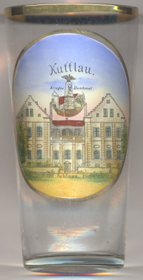
The picture on glass no. 3098 shows a view of
 Kotla palace soldiers' monument
the Polish writer Edward Stachura lived nearby and based his novel “Siekierezada” partly on real events
and characters encountered in the area. In the novel, the village is called ‘Hopla’.
[https://en.wikipedia.org/wiki/Kotla,_Poland, https://de.wikipedia.org/wiki/Kotla,
https://pl.wikipedia.org/wiki/Kotla_(województwo dolnośląskie)]
![[scale]](lineal.jpg)