
|
|
| POLSKA | POLAND |
| województwo: Dolnośląskie | voivodship: Lower Silesia |
| powiat: Wołów | county: Wołów |
map →
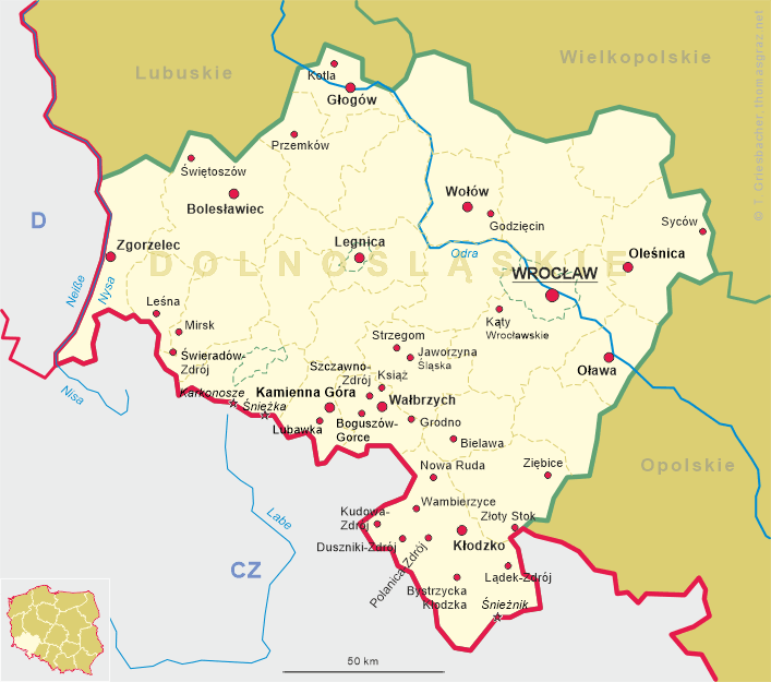
 Godzięcin (former German name: Thiergarten) is situated at an elevation of 252 m in the county (powiat)
Wołów in the voivodship Lower Silesia of southwestern Poland, about 10 km east
of Wołów. Godzięcin has a population of about 670 (2011) and is part of the municipality (gmina) of
Brzeg Dolny.
Godzięcin (former German name: Thiergarten) is situated at an elevation of 252 m in the county (powiat)
Wołów in the voivodship Lower Silesia of southwestern Poland, about 10 km east
of Wołów. Godzięcin has a population of about 670 (2011) and is part of the municipality (gmina) of
Brzeg Dolny.
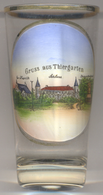
Tyrgarten was first mentioned in 1301.
The former  palace [left, no. 3144: centre]
was first mentioned in documents of 1795, 1830 and 1845. The manor was enlarged in the second half of the
19th century. After the Second World War, the property was taken over by the Polish state and the manor farm and
the residence came under the control of the State Farm. Following reconstructions, especially in 1981–1985,
the building now is a simple brick building with a flat roof, the towers have been demolished, and the windows and
façades were stripped of the decorative elements. Today, it houses the National Children's Home.
palace [left, no. 3144: centre]
was first mentioned in documents of 1795, 1830 and 1845. The manor was enlarged in the second half of the
19th century. After the Second World War, the property was taken over by the Polish state and the manor farm and
the residence came under the control of the State Farm. Following reconstructions, especially in 1981–1985,
the building now is a simple brick building with a flat roof, the towers have been demolished, and the windows and
façades were stripped of the decorative elements. Today, it houses the National Children's Home.
The Protestant chapel in the palace park [left]
today is reduced to ruins.
Depicted on the right of the picture on glass no. 3144 is the
soldiers'
[https://www.palaceslaska.pl/index.php/indeks-alfabetyczny/g/2000-godziecin,
http://www.glogow.pl/okolice/podstrony/wolowski/godziecin.htm,
http://silesia-history.blogspot.cz/2011/05/godziecin-thiergarten.html;
http://fallingrain.com/world/PL/72/Godziecin.html]
![[scale]](lineal.jpg)