
|
|
| DEUTSCHLAND | GERMANY |
| Bundesland: Freistaat Sachsen | Saxony |
| Landkreis: Erzgebirgskreis |
map →

 Zöblitz is situated at an elevation of 600 m in an elevated plain above the river Schwarze Pockau in the
district Erzgebirgskreis (Ore Mountains district) of Germany's state of Saxony. Since 2012/2013 Zöblitz is part of
the municipality of Marienberg.
Zöblitz is situated at an elevation of 600 m in an elevated plain above the river Schwarze Pockau in the
district Erzgebirgskreis (Ore Mountains district) of Germany's state of Saxony. Since 2012/2013 Zöblitz is part of
the municipality of Marienberg.
Zöblitz is likely to have been founded in the 10th/11th century. The earliest written document mentioning Zcobelin dates from 1323 and is taken as evidence that Zöblitz already had the status of a (small) town. The mineral serpentine is thought to have been discovered in the area around 1500. In 1531, the town obtained the status of an 'Unterbergamt' (approx. 'subordinate mountain office') of Freiberg. The Zöblitz serpentine soon gained widespread recognition and the Electors of Saxony even retained the privilage for red serpentine. In 1999, the neighbouring communities of Ansprung (with Sorgau) and Grundau were incorporated into Zöblitz. On 31 December 2012 Zöblitz itself was incorporated into the municipality of Marienberg.
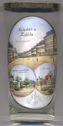
The top picture on glass no. 3166 shows a view of the street
 Johannisstraße
The bottom left picture shows a view of
Marktplatz
The bottom right picture shows another view of the Market Square: depicted on the far right is the
town town
[https://de.wikipedia.org/wiki/Zöblitz]
![[scale]](lineal.jpg)