
|
|
| POLSKA | POLAND |
| województwo: Śląskie | voivodship: Silesia |
| miasto na prawach powiatu: Chorzów | city: Chorzów |
map →
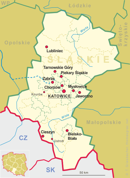
Chorzów (in German: Königshütte) is situated at an elevation of 273 m on the river Rawa, about 8 km northwest of Kattowice in the voivodeship Silesia of southern Poland. The municipality of Chorzów has a population of about 110,100 (2015) and is one of the central districts of the Upper Silesian Metropolitan Union, a metropolitan are with a population of about 2 million.
 In the 12th century, the castellany of Bytom, including the Chorzów area, belonged to the province of
Kraków. In 1179 it was awarded to the Duke of Opole, and since that time the history
of Chorzów has been connected to the history of Upper Silesia. The oldest part of the city, the village of
Chorzów, today called Chorzów Stary, belonged since 1257 to the Equestrian Order of the Holy Sepulchre
of Jerusalem. Already at that time silver and lead ores were mined nearby, later also the ores of iron. From 1327, the
Upper Silesian duchies were ruled by the dukes of the Piast dynasty and were subject to Bohemian overlordship.
In 1742, the area was conquered by Prussia in the First Silesian War. Deposits of bituminous coal were discovered at
the end of the 18th century. In 1791–1797 the Prussian state-owned Royal Coal Mine was constructed. In 1799, first
pig iron was made in the Royal Iron Works. At the time, it was a pioneering industrial establishment of its kind in
continental Europe. Settlements grew near the new coal and iron works. Since 1797, one group of settlements was called
Königshütte (Królewska Huta in Polish) after the iron works. In 1846 Königshütte
received a railway track to Schwientochlowitz (Świętochłowice) and Myslowitz (Mysłowice),
in 1857 to Beuthen (Bytom) and till 1872 to all major cities in the Silesian region. Königshütte
(officially Königshütte O.S. (O.S. = Oberschlesien / Upper Silesia)) received
city status in 1868 as part of the Beuthen district, and in 1898 it was made a separate city-county. In the Upper Silesia
plebiscite of 1921, a majority of 74.5% of voters voted to remain in Germany. Following three Silesian uprisings, the
eastern part of Silesia, including Chorzow and Königshütte, was separated from Germany and awarded to Poland
in 1922. The city of Chorzów was formed in 1934–1939 by a merger of Chorzów (Chorzow),
Królewska Huta (Königshütte), Nowe Hajduki (Neu Haiduk) and Hajduki Wielkie (Alt Haiduk).
The name of the oldest settlement, Chorzów was, applied to the amalgamated city. During World War II,
Chorzów was occupied by German forces and was renamed Königshütte again. After the war, the occupied
areas were returned to Poland. In 2007, Chorzów became a part of Upper Silesian Metropolitan Union, a voluntary union
of a continuous chain of fourteen cities aimed at increasing the poor visibility of the area, improving its competitiveness,
and modernizing the infrastructure.
In the 12th century, the castellany of Bytom, including the Chorzów area, belonged to the province of
Kraków. In 1179 it was awarded to the Duke of Opole, and since that time the history
of Chorzów has been connected to the history of Upper Silesia. The oldest part of the city, the village of
Chorzów, today called Chorzów Stary, belonged since 1257 to the Equestrian Order of the Holy Sepulchre
of Jerusalem. Already at that time silver and lead ores were mined nearby, later also the ores of iron. From 1327, the
Upper Silesian duchies were ruled by the dukes of the Piast dynasty and were subject to Bohemian overlordship.
In 1742, the area was conquered by Prussia in the First Silesian War. Deposits of bituminous coal were discovered at
the end of the 18th century. In 1791–1797 the Prussian state-owned Royal Coal Mine was constructed. In 1799, first
pig iron was made in the Royal Iron Works. At the time, it was a pioneering industrial establishment of its kind in
continental Europe. Settlements grew near the new coal and iron works. Since 1797, one group of settlements was called
Königshütte (Królewska Huta in Polish) after the iron works. In 1846 Königshütte
received a railway track to Schwientochlowitz (Świętochłowice) and Myslowitz (Mysłowice),
in 1857 to Beuthen (Bytom) and till 1872 to all major cities in the Silesian region. Königshütte
(officially Königshütte O.S. (O.S. = Oberschlesien / Upper Silesia)) received
city status in 1868 as part of the Beuthen district, and in 1898 it was made a separate city-county. In the Upper Silesia
plebiscite of 1921, a majority of 74.5% of voters voted to remain in Germany. Following three Silesian uprisings, the
eastern part of Silesia, including Chorzow and Königshütte, was separated from Germany and awarded to Poland
in 1922. The city of Chorzów was formed in 1934–1939 by a merger of Chorzów (Chorzow),
Królewska Huta (Königshütte), Nowe Hajduki (Neu Haiduk) and Hajduki Wielkie (Alt Haiduk).
The name of the oldest settlement, Chorzów was, applied to the amalgamated city. During World War II,
Chorzów was occupied by German forces and was renamed Königshütte again. After the war, the occupied
areas were returned to Poland. In 2007, Chorzów became a part of Upper Silesian Metropolitan Union, a voluntary union
of a continuous chain of fourteen cities aimed at increasing the poor visibility of the area, improving its competitiveness,
and modernizing the infrastructure.
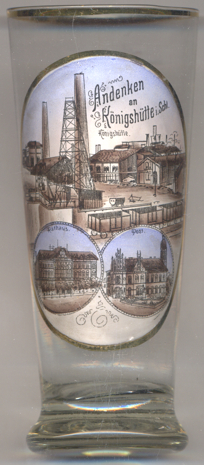
The top picture on glass no. 3201 shows a view of the  Königshütte steel works.
The
The
[https://de.wikipedia.org/wiki/Chorzów, https://de.wikipedia.org/wiki/Chorzów;
https://de.wikipedia.org/wiki/Rathaus_(Chorzów);
https://de.wikipedia.org/wiki/Germaniadenkmal_(Königshütte);
http://fallingrain.com/world/PL/83/Chorzow.html]
Town Hall Post office
![[scale]](lineal.jpg) contact: webmaster
contact: webmaster