
|
|
| DEUTSCHLAND | GERMANY |
| Bundesland: Freistaat Bayern | Bavaria |
| Regierungsbezirk: Unterfranken | |
| Kreis: Main-Spessart |
map →

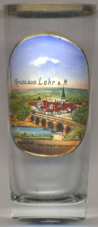
Lohr am Main (officially: Lohr a. Main) is situated at an elevation of 161 m on the Main river, about halfway between Würzburg and Aschaffenburg. The municipality has a population of about 15,100 (2015). It is also the seat of, but not part of, the administrative union Lohr am Main (Neuendorf, Neustadt a. Main, Rechtenbach and Steinfeld).
 The town was settled no later than the 8th century, and by the time of its first documentary mention in 1295 it was
already the main centre of the County of Rieneck. In 1333 Lohr was granted town rights following a disagreement about
the inheritance of the Counts of Rieneck-Rothenfels, which had died out. The town lords were the Counts of Rieneck, who
had been enfeoffed by the Archbishop of Mainz (evidence of this is only available beginning
in 1366). In 1559, after the death of the last Count of Rieneck the fief passed to the Archbishopric of Mainz. The former
Oberamt of the Prince-Bishopric of Würzburg was secularized in favour of Prince Primate
von Dalberg's Principality of Aschaffenburg and passed along with this state in 1814 (by
this time it had become a part of the Grand Duchy of Frankfurt) to the Kingdom of Bavaria.
From 1972 to 1978, the surrounding communities of Halsbach, Rodenbach, Ruppertshütten, Sackenbach, Steinbach, Wombach and
Pflochsbach were amalgamated with the town. In 1972, the greater part of the District Lohr became part of the new
District Mittelmain, which in 1973 was given its current name, Main-Spessart. At first, Lohr am Main was chosen as the
district seat, but in October 1972 it was decided that Karlstadt would be the new district seat.
The town was settled no later than the 8th century, and by the time of its first documentary mention in 1295 it was
already the main centre of the County of Rieneck. In 1333 Lohr was granted town rights following a disagreement about
the inheritance of the Counts of Rieneck-Rothenfels, which had died out. The town lords were the Counts of Rieneck, who
had been enfeoffed by the Archbishop of Mainz (evidence of this is only available beginning
in 1366). In 1559, after the death of the last Count of Rieneck the fief passed to the Archbishopric of Mainz. The former
Oberamt of the Prince-Bishopric of Würzburg was secularized in favour of Prince Primate
von Dalberg's Principality of Aschaffenburg and passed along with this state in 1814 (by
this time it had become a part of the Grand Duchy of Frankfurt) to the Kingdom of Bavaria.
From 1972 to 1978, the surrounding communities of Halsbach, Rodenbach, Ruppertshütten, Sackenbach, Steinbach, Wombach and
Pflochsbach were amalgamated with the town. In 1972, the greater part of the District Lohr became part of the new
District Mittelmain, which in 1973 was given its current name, Main-Spessart. At first, Lohr am Main was chosen as the
district seat, but in October 1972 it was decided that Karlstadt would be the new district seat.
The history of the  parish church Sankt Michael [background right] goes back
to the 13th century. The parish was first mentioned in 1295. The original church was dedicated to St. Martin.
The sacristy of today was built in the 12th century, at first as a cemetry chapel. Around 1300, this church was enlarged
by the addition of side naves to the north and south. Major transformations from the prior Romanesque to a Gothic church
were carried out in 1488–1500. The west tower was built in 1496. Further modifications followed in the 19th and
20th centuries.
parish church Sankt Michael [background right] goes back
to the 13th century. The parish was first mentioned in 1295. The original church was dedicated to St. Martin.
The sacristy of today was built in the 12th century, at first as a cemetry chapel. Around 1300, this church was enlarged
by the addition of side naves to the north and south. Major transformations from the prior Romanesque to a Gothic church
were carried out in 1488–1500. The west tower was built in 1496. Further modifications followed in the 19th and
20th centuries.
The Old Main Bridge [foreground] was built in 1871–1875. The red
sandstone bridge has a length of 296 metres and crosses the river in 6 spans of 29–30 metres each. In March 1945
the German army blew up one of the pillars. After the war, the pillar and the two adjacent spans were reconstructed
in concrete (cased in red sandstone); the bridge was reopened in May 1946.
contact: webmaster