
|
|
| ČESKÁ REPUBLIKA | CZECH REPUBLIC |
| Liberecký kraj | Liberec region |
| Okres: Liberec |
map →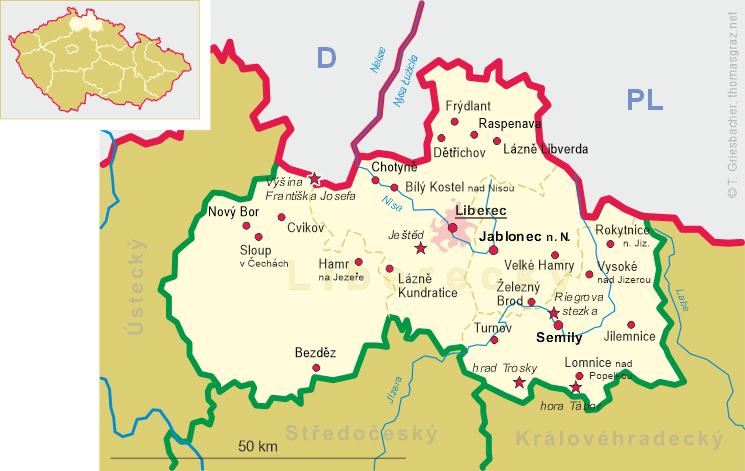
Raspenava (German: Raspenau) is situated at an elevation of 331 m in the Smědá valley in the foothills of the Jizera Mountains in the north of the district Liberec. The municipalit has a population of about 2,800 (2017) and includes the settlements Luh (Mildenau), Lužec (Mildeneichen), Peklo (Karolinthal), Raspenava (Raspenau), U Dvora (Meierhofhäuser) und V Lukách (Wiesenschenke).
Raspenau, Mildenau and Mildeneichen were first mentioned at the end of the 14th century in a tax register of the Friedland (Frýdlant) domains. In the 16th century, iron mining and the establishment of a hammer mill became important; however, the destructions of the Thirty Years' War (1618–1648) ended these activities. It took until the industrialisation of the 18th century that Raspenau prospered again. Following the Munich Agreement of 1938, the region was annexed to Germany and remained in the German district Friedland until 1945. After World War II, the town was returned to Czechoslovakia and the German-speaking population was expelled. Today, Raspenava profits from tourism in the Jizera Mountains.
![0000 Raspenava [Luh]](glas3377.jpg)
Luh (German: Mildenau) [left, no. 3377] was first mentioned at the end of the
14th century. The German name Mildenau was used until 1945 when it was changed to the Czech, Luh.
Luh is the starting point for several tourist hiking trails.
[https://de.wikipedia.org/wiki/Raspenava, https://cs.wikipedia.org/wiki/Luh_(Raspenava)]
![[scale]](lineal.jpg)