
|
|
| POLSKA | POLAND |
| województwo: Zachodniopomorskie | voivodship: West Pomerania |
| powiat: Stargard | county: Stargard |
map →
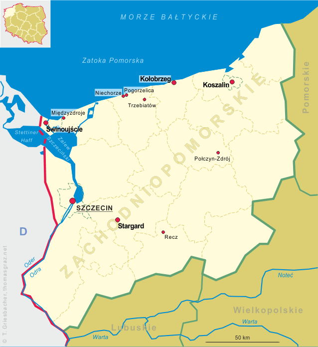
Stargard is situated at an elevation of 20 m on the left bank of the river Ina, about 32 km southeast of Szczecin. The municipality has a population of about 68,500 (2016).
Stargard, which was first mentioned in around 1140 and received Magdeburg city rights in 1243 from Barnim I, Duke of Pomerania. It was one of the most important towns in Duchy of Pomerania. In 1363 the city joined the Hanseatic League of tradig towns and was then strongly fortified. During the 15th century the Pomeranian dukes chose it as their residence. During the Thirty Years' War the city burnt down and in the 1648 Peace of Westphalia it was incorporated, together with the rest of Further Pomerania, into Brandenburg-Prussia. In 1701 Stargard became part of the Kingdom of Prussia and in 1818, after the Napoleonic Wars, Stargard became part of the new district Saatzig (today Sadzko) within the Province of Pomerania. As a result of the unification of Germany in 1871 the city became part of the German Empire. In 1901 it became an independent city, separate from the Saatzig district. During World War II the large prisoner-of-war camp Stalag II-D was located near Stargard. After World War II the region was placed under Polish administration by the Potsdam Agreement. Most Germans fled or were expelled and were replaced with Poles expelled from the Polish areas annexed by the Soviet Union. In 1950, the town was renamed Stargard Szczeciński. On 1 January 2016, the name was officially changed back to Stargard.
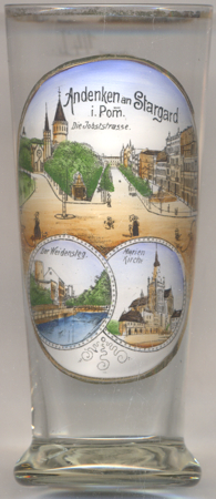 The top picture on glasss no. 3440 is labeled Jobststraße (Jodocus Street), but it actually
shows Hindenburgstraße (today Hetmana Stefana Czarnieckiego) [top picture: centre].
The entire quarter developed rapidly after the railway station had been opened in 1846 (1848 railroad
Stettin/Szczecin – Posen/Poznań).
The town quarter was named for St. Jodocus (Jobst); a chapel of St. Jodocus stood near here until 1867.
The square in foreground at the time had been called Gerichtsplatz (Court Square); it was renamed
Adolf-Hitler-Platz in 1933, plac Józefa Stalina after World War II, and finlly
plac Wolności (Peace Square) in 1956.
The top picture on glasss no. 3440 is labeled Jobststraße (Jodocus Street), but it actually
shows Hindenburgstraße (today Hetmana Stefana Czarnieckiego) [top picture: centre].
The entire quarter developed rapidly after the railway station had been opened in 1846 (1848 railroad
Stettin/Szczecin – Posen/Poznań).
The town quarter was named for St. Jodocus (Jobst); a chapel of St. Jodocus stood near here until 1867.
The square in foreground at the time had been called Gerichtsplatz (Court Square); it was renamed
Adolf-Hitler-Platz in 1933, plac Józefa Stalina after World War II, and finlly
plac Wolności (Peace Square) in 1956.
The former Protestant  Christuskirche [top picture: far left]
was built in 1890 in historicist neo-Gothic style. After World War II it was used as a Catholic church until 1951.
In 1953 it was obtained by the Orthodox community and since then is named Church of the Holy Apostles Peter and Paul.
Christuskirche [top picture: far left]
was built in 1890 in historicist neo-Gothic style. After World War II it was used as a Catholic church until 1951.
In 1953 it was obtained by the Orthodox community and since then is named Church of the Holy Apostles Peter and Paul.
The water tower [top picture: left background]
was built in 1896–1897. At a height of 65 metres, it is the highest water tower in Poland. It has a
capacity of 500 cubic metres.
The bottom left picture shows a view of Weidensteg.
The Prisoners' Tower (Baszta Jeńców) [bottom left picture: left]
was built at the turn of the 15th/16th century in the southern part of the fortifications running along the banks of the
Ina river. The cylindrical tower has a height of 13 metres. In 2010 it was listed as a historic monument.
St. Mary's Church [bottom right picture]
is perhaps the most valuable architectural monument in Polish Western Pomerania. It closes the eastern part of the Old Town
Market. The monument is a part of the European Route of Brick Gothic. It is a collegiate church, but it is commonly called
"the Cathedral". The oldest known mention of the church dates from 1248. The church, in a quickly developing Stargard,
became too small for regular attendants. In 1292, construction started on a new and more impressive place of worship. In
this phase, the church had a three nave structure, with all naves of equal height. The church had no tower then. In the
period from 1388 to about 1500, the last expansion of the structure emerged with the construction of the presbytery and
towers. In 2010, it was listed as a national historic monument.
[https://de.wikipedia.org/wiki/Stargard, https://en.wikipedia.org/wiki/Stargard, https://pl.wikipedia.org/wiki/Stargard;
https://books.google.at/books?id=olXnBQAAQBAJ;
https://pl.wikipedia.org/wiki/Plac_Wolno%C5%9Bci_w_Stargardzie;
http://pomorzezachodnie.travel/de/Poi/a,4174/Orthodoxe_Kirche_der_Hl_Aposteln_Peter_und_Paul_Cerkiew_Swietych_Apostolow_Piotra_i_Pawla_DE;
http://pomorzezachodnie.travel/de/Poi/a,6197/Der_Wasserturm_DE;
https://pl.wikipedia.org/wiki/Baszta_Jeńców;
https://en.wikipedia.org/wiki/St._Mary%27s_Church,_Stargard]
![[scale]](lineal.jpg)