
|
|
| POLSKA | POLAND |
| województwo: Warmińsko-Mazurskie | voivodship: Warmia and Masuria |
| powiat: Iławski | county: Iława |
map →

 Iława (former German name: Deutsch Eylau) is situated at an elevation of 100 m on the southern
shore of the lake Jeziorak (Geserichsee), about 45 km southeast of Kwidzyn (Marienwerder) and 61 km southwest of
Olsztyn (Allenstein). Iława is the seat of the administration of the district of the same
name. The municipality has a population of about 33,100 (2016).
Iława (former German name: Deutsch Eylau) is situated at an elevation of 100 m on the southern
shore of the lake Jeziorak (Geserichsee), about 45 km southeast of Kwidzyn (Marienwerder) and 61 km southwest of
Olsztyn (Allenstein). Iława is the seat of the administration of the district of the same
name. The municipality has a population of about 33,100 (2016).
The origins of the town go back to the early Middle Ages, when an old prusssian settlement existed here. During the colonisation of the area by the Teutonic Order, the order founded a castle on a peninsula of the lake. The town was founded in 1305 by the knight commander of the Kommende (commandry) Christburg (today Dzierzgoń) and received town rights in 1317. Later documents (1388) mention the name as Ylavia, Ylaw and Ylau. The Latin name Ylow theutonicalis, used in documents from the 15th century, became the origin of the German name Deutsch Eylau (in order to distinguish it from Preußisch Eylau in East Prussia, today Bagrationovsk, Russia). Deutsch Eylau belonged to the commandry of Christburg until 1340 when it was reassigned to the commandry of Osterode (today Ostróda). With the secularisation of the Teutonic Order in 1525, Deutsch Eylau became part of the Duchy of Prussia. In 1719 Deutsch Eylau became a garrison town. After the administrative reorganisation of Prussia in 1815 the town was part of the district (Kreis) Rosenberg in Westpreußen (today Susz). The economy of the town was improved in 1822 by the acquisition of the fishing right in the Geserichsee lake, the construction of the Elbląg Canal in 1860, and the connection in 1872 to the railroad from Thorn (Toruń) via Allenstein (Olsztyn) to Insterburg (Черняховск/Černjahovsk). In a plebiscite held in 1920 after World War I, 95% of the city's population voted for remaining in Germany (administrative district West Prussia within the province East Prussia). After World War II in 1945 the remaining German population was expelled and the name of the town was officially changed to the Polish name Iława. Today, Iława and the lake Jezioro are a popular centre for water sports tourism.
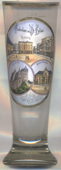
The top picture on glass no. 3517 [left] shows a view of the
 market square
The Catholic parish church of Our Lady [bottom left picture]
was built in 1317–1325 in Brick Gothic style. Prior to this, there already had been a chapel dedicated to
St. Nicholas. The church was enlarged in 1548 and 1550, including the addition of the church tower with its
characteristic crow-stepped gable; further enlargements followed in 1642 and 1904. After the secularisation of the
state of the Teutonic Order and its transformation into the Protestant Duchy of Prussia, the church served the
Reformed community. After 1945 it became the Catholic parish church of Iława.
The bottom right picture shows a view of the
Imperial
The former German name of Iława was Deutsch Eylau (German Eylau). Another glass in this collection is a souvenir from
Bagrationovsk (RUS), the former name of which was Preußisch Eylau (Prussian Eylau).
[https://de.wikipedia.org/wiki/Iława;
https://ilawa.fotopolska.eu/158249,str.html, https://pl.wikipedia.org/wiki/Władysław_Bandurski]
![[scale]](lineal.jpg)