
|
|
| ČESKÁ REPUBLIKA | CZECH REPUBLIC |
| Moravskoslezský kraj | North Moravia and Silesia (Ostrava) region |
| Okres: Frýdek-Místek |
map →

 The Prašivá (843 m) is a hill in the Moravian-Silesian Beskids. The ridge starts at the
peak of the Mala Prašivá (706 m) and is also connected to the Čupel (872 m). The top
is located in the cadastral areas of Vyšní Lhoty and Komorní Lhotka. For tourists it is accessible
from Vyšní Lhoty (bus), Dobratice (train) and Komorní Lhotka.
The Prašivá (843 m) is a hill in the Moravian-Silesian Beskids. The ridge starts at the
peak of the Mala Prašivá (706 m) and is also connected to the Čupel (872 m). The top
is located in the cadastral areas of Vyšní Lhoty and Komorní Lhotka. For tourists it is accessible
from Vyšní Lhoty (bus), Dobratice (train) and Komorní Lhotka.
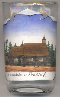
The Roman Catholic  church of St. Anthony of Padua [left] is a wooden
chapel standing on top of the Mala Prašivá (Prašivka) and is a significant pilgrimage site in the
area of Český Těšín. The church was built in 1640 and was
originally dedicated to St. Igantius of Loyola. At that time it was a filial church of the parish of
Frýdek although it was located within the area of the parish of Dobrá.
The patrocinium was changed in 1791. In the following period, the church became a popular pilgrimage site. After the
Munich Agreement of 1938, the church became part of Poland (Zaolzie, Olza River area).
In 1940, pilgrimages were definitely forbidden. After World War II, the area was restituted to Czechoslovakia.
Pilgrimages took place again from the 1950s, although in the 1950s outdoor worship had been banned. Repairs and
renovations took place in 1975 and 2001–2005. A new turret was built in 2006.
church of St. Anthony of Padua [left] is a wooden
chapel standing on top of the Mala Prašivá (Prašivka) and is a significant pilgrimage site in the
area of Český Těšín. The church was built in 1640 and was
originally dedicated to St. Igantius of Loyola. At that time it was a filial church of the parish of
Frýdek although it was located within the area of the parish of Dobrá.
The patrocinium was changed in 1791. In the following period, the church became a popular pilgrimage site. After the
Munich Agreement of 1938, the church became part of Poland (Zaolzie, Olza River area).
In 1940, pilgrimages were definitely forbidden. After World War II, the area was restituted to Czechoslovakia.
Pilgrimages took place again from the 1950s, although in the 1950s outdoor worship had been banned. Repairs and
renovations took place in 1975 and 2001–2005. A new turret was built in 2006.
[https://cs.wikipedia.org/wiki/Prašivá_(Moravskoslezský_Beskydy);
https://cs.wikipedia.org/wiki/Kostel_svatého_Antonína_Paduánského_(Prašivá)]
![[scale]](lineal.jpg)