
|
|
| DEUTSCHLAND | GERMANY |
| Bundesland: Freistaat Sachsen | Saxony |
| Landkreis: Sächsische Schweiz-Osterzgebirge |
map →

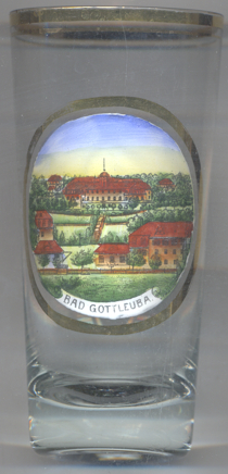 Bad Gottleuba is situated at an elevatin of 334 m about 45 km southeast of Dresden.
Bad Gottleuba is part of the municipality og Bad Gottleuba-Berggießhübel, which has a population of about
5,600 (2017).
Bad Gottleuba is situated at an elevatin of 334 m about 45 km southeast of Dresden.
Bad Gottleuba is part of the municipality og Bad Gottleuba-Berggießhübel, which has a population of about
5,600 (2017).
Gottleuba was first mentioned in 1363 as Gotlavia, but probably already existed at the end of the 13th century.
In 1298 Gottleuba together with Pirna became a part of Bohemia. In 1405 Pirna and Gottleuba were
taken back by the Margrave of Meißen. Already at the end of the 14th century Gottleuba was a
center for mining, mainly iron, silver and copper. The last silver mine was closed in 1889. In 1463, Gottleuba received town
privileges. In the 16th century, Gottleuba developed guilds with special commercial laws (for example, holding of spring and
autumn markets and grant of weekly markets). Wars, disease, large town fires in 1746 and 1865 and the flood disasters of
1552, 1897 and 1927 and 1957 again brought considerable setbacks to the city. In 1936 the name was officially changed to
Bad Gottleuba, recognising its importance as a spa town. The municipality of Bad Gottleuba-Berggießhübel
was formed on 1 January 1999 by the merger of the former municipalities Bad Gottleuba, Berggießhübel,
Langenhennersdorf and Bahratal.
[https://de.wikipedia.org/wiki/Bad_Gottleuba-Berggießhübel, https://en.wikipedia.org/wiki/Bad_Gottleuba-Berggießhübel]
![[scale]](lineal.jpg)