
|
|
| DEUTSCHLAND | GERMANY |
| Bundesland: Freistaat Bayern | Bavaria |
| Regierungsbezirk: Oberbayern | |
| Landkreis: Weilheim-Schongau |
map →

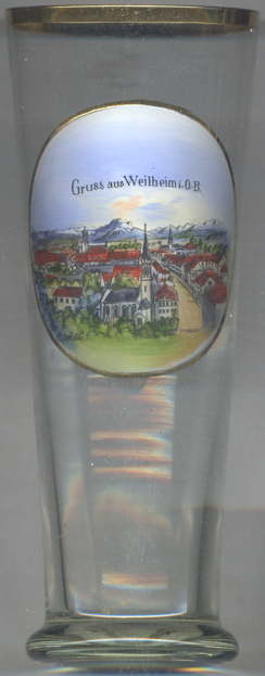 Weilheim in Oberbayern (official name: Weilheim i. OB) is situated at an elevation of 563 m on the
river Ammer in Upper Bavaria. It is one of the centres of the Pfaffenwinkel region and is the seat of the district
Weilheim-Schongau. The municipality has a population of about 22,400 (2017).
Weilheim in Oberbayern (official name: Weilheim i. OB) is situated at an elevation of 563 m on the
river Ammer in Upper Bavaria. It is one of the centres of the Pfaffenwinkel region and is the seat of the district
Weilheim-Schongau. The municipality has a population of about 22,400 (2017).
The oldest traces of human settlements date from the Bronze Age. Wilhain was first mentioned in a written document of 1010 AD. During the times of the Plague, 1521, the Bavarian dukes Wilhelm IV and Ludwig X temporarily resided here.
The late Gothic  cemter church Sankt Salvator und Sebastian [foreground]
dates from 1449, the polygonal choir and the sacristy were added in 1481. The power part of the tower was built in
1526, the upper part in 1583, the pitched roof was added in 1852.
cemter church Sankt Salvator und Sebastian [foreground]
dates from 1449, the polygonal choir and the sacristy were added in 1481. The power part of the tower was built in
1526, the upper part in 1583, the pitched roof was added in 1852.
The Catholic parish church Mariä Himmelfahrt (Ascension of Our Lady) [background
left] was rebuilt in 1624/1631. The lower parts of the church, remainders of the previous church, date from
the 14th century, the upper part of the tower was built in 1573.
[https://de.wikipedia.org/wiki/Weilheim_in_Oberbayern]
![[scale]](lineal.jpg)