
|
|
| DEUTSCHLAND | GERMANY |
| Bundesland: Hessen | Hesse |
| Regierungsbezirk: Darmstadt | |
| Kreis: Bergstraße |
map →
Bensheim ... [Text in preparation]is situated at an elevation of 115 m in the foothills of the western Odenwald mmountains on the Bergstraße touristic road, about 5 km north of Heppenheim, the administrative seat of the district Bergstraße in the slth of Germany's state of Hesse. The municipality has a population of about 40,500 (2018).
In 765, Basinsheim had its first documentary mention in the Lorsch Abbey’s Codex Laureshamensis. The name changed
from Basinsheim to Basinusheim and then to Besensheim, finally becoming Bensheim. Noteworthy is that
the rights as a market town were granted early on by Emperor Otto I in 956 AD. When the town came in possession
of Lorsch Abbey it became part of the Electorate of Mainz and likely received town rights only a
few decades later, which is, however, only documented by a certificate issued in 1320. In the time of the pledging to the
counts palatine of the Rhine from 1461 to 1650, Bensheim experienced a boom, but as a Palatinate town, however, it was
embroiled in the Bavarian–Palatine war of succession in 1504. In 1650, after just under 200 years of being pledged to
the Electorate of the Palatinate, Bensheim was once again redeemed by the Archbishopric of Mainz. By the
Reichsdeputationshauptschluss in 1803, Bensheim passed to the Landgraviate of Hesse-Darmstadt,
which joined the Confederation of the Rhine in 1806 and was raised to a Grand Duchy. Bensheim became the seat of the
 Landratsbezirk (an administrative region) of Bensheim in the province of Starkenburg, which in 1832 was merged with the
Landratsbezirk of Heppenheim to form the district of Bensheim (Kreis Bensheim) with Bensheim as its seat. In 1938, the
districts of Bensheim and Heppenheim were merged into one district, Kreis Bergstraße with Heppenheim as its seat. In 1971,
the neighbouring communities of Langwaden, Schwanheim, Fehlheim, Hochstädten, Gronau and Wilmshausen were merged with
the municipality of Bensheim.
Landratsbezirk (an administrative region) of Bensheim in the province of Starkenburg, which in 1832 was merged with the
Landratsbezirk of Heppenheim to form the district of Bensheim (Kreis Bensheim) with Bensheim as its seat. In 1938, the
districts of Bensheim and Heppenheim were merged into one district, Kreis Bergstraße with Heppenheim as its seat. In 1971,
the neighbouring communities of Langwaden, Schwanheim, Fehlheim, Hochstädten, Gronau and Wilmshausen were merged with
the municipality of Bensheim.
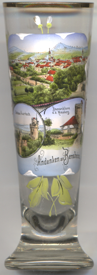
 Auerbach Castle [left, no. 3773: bottom left picture]
is one of several fortresses along the Bergstraße. The castle was originally built by King Charlemagne (Emperor of
the Holy Roman Empire) and rebuilt the counts of Katzenelnbogen in the second quarter of the
13th century. Today it remains standing atop a hill known as Urberg (part of the Melibokus) above Auerbach (today
part of Bensheim. Auerbach was als mentioned first in the Lorsch Codex. In 1135 it passed by marriage to the lords (1138
counts) of Katzenelnbogen. The castle itself was first mentioned in 1247/1257. In 1479 it passed to the Landgraviate of
Hesse. The castle lost much of its strategic importance during the 16th century until, by the time of the Thirty Years' War
(1618–1648), it was no longer in military use. In 1674 (during the 1672–1679 Franco–Dutch War) the castle
was conquered and set afire by French troops. The abandoned castle became a ruin over the following years. In 1820 the north
tower of the castle collapsed, after which the Landgraviate of Hesse decided to secure (and partially rebuild) the ruins.
In 1888 an inn was built in the former bailey, which was open year-round. During the 1950s, the south tower became
inaccessible due to the deterioration of its wooden staircase. In 1989, construction began on a terraced restaurant; it
opened the following year, increasing the attraction of the castle ruins to visitors. In 2007, the stairway in the south
tower was repaired and reopened to the public.
Auerbach Castle [left, no. 3773: bottom left picture]
is one of several fortresses along the Bergstraße. The castle was originally built by King Charlemagne (Emperor of
the Holy Roman Empire) and rebuilt the counts of Katzenelnbogen in the second quarter of the
13th century. Today it remains standing atop a hill known as Urberg (part of the Melibokus) above Auerbach (today
part of Bensheim. Auerbach was als mentioned first in the Lorsch Codex. In 1135 it passed by marriage to the lords (1138
counts) of Katzenelnbogen. The castle itself was first mentioned in 1247/1257. In 1479 it passed to the Landgraviate of
Hesse. The castle lost much of its strategic importance during the 16th century until, by the time of the Thirty Years' War
(1618–1648), it was no longer in military use. In 1674 (during the 1672–1679 Franco–Dutch War) the castle
was conquered and set afire by French troops. The abandoned castle became a ruin over the following years. In 1820 the north
tower of the castle collapsed, after which the Landgraviate of Hesse decided to secure (and partially rebuild) the ruins.
In 1888 an inn was built in the former bailey, which was open year-round. During the 1950s, the south tower became
inaccessible due to the deterioration of its wooden staircase. In 1989, construction began on a terraced restaurant; it
opened the following year, increasing the attraction of the castle ruins to visitors. In 2007, the stairway in the south
tower was repaired and reopened to the public.
The Bismarck tower [left, no. 3773: bottom right picture] on the
Hemsberg (262 m), often called Hemsbergturm, was built in 1897–1902 to commemorate Otto von Bismarck, the
first Chancellor (1871–1890) of the German Empire. The round tower has a height of 19 metres. On its southeastern
side an elevated platform covered by a hipped roof served as a visitors area. The open parts below the roof were closed by
walls and windows in the 1950s.
[https://de.wikipedia.org/wiki/Bensheim, https://en.wikipedia.org/wiki/Bensheim;
https://en.wikipedia.org/wiki/Auerbach_Castle;
https://de.wikipedia.org/wiki/Bismarckturm_(Bensheim)]
![[scale]](lineal.jpg)