
|
|
| DEUTSCHLAND | GERMANY |
| Bundesland: Baden-Württemberg | |
| Regierungsbezirk: Freiburg | |
| Landkreis: Rottweil |
map →

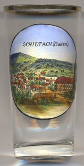 Schiltach is situated at an elevation of 330 m in the eastern Black Forest at the confluence of the Schiltach
and Kinzig rivers in the district Rottweil. The municipality has a population of about 3,800 (2018).
Schiltach is situated at an elevation of 330 m in the eastern Black Forest at the confluence of the Schiltach
and Kinzig rivers in the district Rottweil. The municipality has a population of about 3,800 (2018).
Already in Roman times the road through the Kinzig valley was already part of a link through the Black Forest from the
Strasbourg area towards Rottweil. Schiltach was founded in the
11th century as a parish for the surrounding farms, which are older than Schiltach. The town itself was fonded by the
dukes of Teck in the middle of the 13th century to secure their territories. The town was
intended to act as a stop for travellers and as a trading post before the road descended to Rottweil. From about 1250, the
castle and town took over the function of the Willenburg, which had guarded the road before the founding of Schiltach.
In 1371 Schiltach was transferred to the Dukes of Urslingen. After ten years, the impoverished dukes of Urslingen sold the
castle and town to the Dukes of Württemberg. Württemberg retained Schiltach until 1810 except the years from 1519
to 1534, when Schiltach was occupied by the free imperial city of Rottweil and later (like the whole Duchy of Württemberg)
by Further Austria. In a border treaty between the Kingdom of Württemberg and the Grand Duchy of
Baden, which was negotiated in Paris in 1810, several areas of the
Oberamt Hornberg, besides Schiltach also the town of Hornberg and the communities Gutach and Kirnbach, were allocated to the
Grand Duchy of Baden. Wolfach became the new Amststadt of Schiltach and later the county town. The county of Wolfach was
dissolved in 1973 and Schiltach was allocated to the district Rottweil.
[https://de.wikipedia.org/wiki/Schiltach, https://en.wikipedia.org/wiki/Schiltach]
![[scale]](lineal.jpg)