
|
|
| ČESKÁ REPUBLIKA | CZECH REPUBLIC |
| Pardubický kraj | Pardubice region |
| Okres: Chrudim |
map →
 Seč is situated at an elevation of 532 m on the left bank of the Chrudimka stream in the western part
of the Iron Mountains (Železné hory) of the Bohemian-Moravian Highlands, about 15 km southwest of the
sgrict town Chrudim and about 25 km southwest of the regional capital
Pardubice. The municipality has a population of about 1,700 (2019).
Seč is situated at an elevation of 532 m on the left bank of the Chrudimka stream in the western part
of the Iron Mountains (Železné hory) of the Bohemian-Moravian Highlands, about 15 km southwest of the
sgrict town Chrudim and about 25 km southwest of the regional capital
Pardubice. The municipality has a population of about 1,700 (2019).
Syez was first mentioned in a written docuent dating from 1318. In 1499 it was mentioned for the first time as market town. In 1853 Seč obtained the status of a town; however, this status was not renewed after World War II and the municipality only regained this status in 2007.
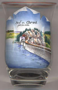
 Seč dam [left, no. 3903] is the largest dam in the protected
landscape area Iron Mountains. It is located on river Chrudimka in a valley just south of Seč. The dam was
constructed between 1925 and 1934 as a protection against floods. As a result of the construction, 22 buildings were
depopulated and flooded. Remains of some of them are popular destination for scuba divers. A small power plant was
constructed between 1941 and 1946. In 1947 another smaller reservoir (Seč II) was constructed approx 1 km
downstream from the main reservoir (Seč I).
Seč dam [left, no. 3903] is the largest dam in the protected
landscape area Iron Mountains. It is located on river Chrudimka in a valley just south of Seč. The dam was
constructed between 1925 and 1934 as a protection against floods. As a result of the construction, 22 buildings were
depopulated and flooded. Remains of some of them are popular destination for scuba divers. A small power plant was
constructed between 1941 and 1946. In 1947 another smaller reservoir (Seč II) was constructed approx 1 km
downstream from the main reservoir (Seč I).
[https://de.wikipedia.org/wiki/Se%C4%8D_u_Nasavrk;
https://en.wikipedia.org/wiki/Se%C4%8D_Dam]
![[scale]](lineal.jpg)