
|
|
| ČESKÁ REPUBLIKA | CZECH REPUBLIC |
| Středočeský kraj | Central Bohemia region |
| Okres: Praha-východ | district: Prague-East |
map →
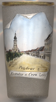 Kostelec nad Černými lesy (German: Schwarzkosteletz) is situated at an elevation of 391 m in the southeast of the district Prague-east, about 30 km
southeast of the capital's centre. The municipality has a population of about 3,800 (2021).
Kostelec nad Černými lesy (German: Schwarzkosteletz) is situated at an elevation of 391 m in the southeast of the district Prague-east, about 30 km
southeast of the capital's centre. The municipality has a population of about 3,800 (2021).
The area was colonised in the 13th century. The earliest known document that mentions Costelicz in Nygra Sylva dates from 1348. In 1489 it obtained the status of a market town. In 1920, the name of the town was officially changed from Černý Kostelec to Kostelec nad Černými lesy.
The  parish church of the Holy Guardian Angels (kostel svatý Andělů strážných)
[left, no. 3994: background left] was built in 1735–1737 in Baroque style. The fron tower was added in 1892–1894.
parish church of the Holy Guardian Angels (kostel svatý Andělů strážných)
[left, no. 3994: background left] was built in 1735–1737 in Baroque style. The fron tower was added in 1892–1894.
[https://de.wikipedia.org/wiki/Kostelec_nad_%C4%8Cern%C3%BDmi_lesy, https://cs.wikipedia.org/wiki/Kostelec_nad_%C4%8Cern%C3%BDmi_lesy]
![[scale]](lineal.jpg)