
|
|
| DEUTSCHLAND | GERMANY |
| Bundesland: Freistaat Sachsen | Saxony |
| Landkreis: Zwickau |
map →

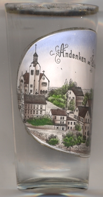
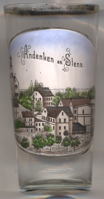 Stenn is situated at an elevation of 352 m on the river Pleiße, about 8 km soutwest of Zwickau.
The village has a population of about 1,200 (2020) and is part of the municipality of Lichtentanne.
Stenn is situated at an elevation of 352 m on the river Pleiße, about 8 km soutwest of Zwickau.
The village has a population of about 1,200 (2020) and is part of the municipality of Lichtentanne.
The area was colonised after about 1000 AD. The earliest mention of Steynen dates from 1386; the modern name, Stenn, is documented as early as 1532. Mining for copper and iron presumably began in the 14th century, but is documented only since the 16th century. In modern times, the railway line from Zwickau to Falkenstein connected Stenn to the railroad network. Since 1 January 1996 Stenn is part of the municipality Lichtentanne.
The  church of the Resurrection of Our Lord [left, no. 4035: far left] is one of the oldest village
churches in Saxony. The old church from 1430 was dedicated to St. Leonhard; it was demolished in 1895. The new church was built by the architects
Rudolf Schilling and Julius Graebner and was consecrated in 1895. It is one of the largest village churches in Saxony.
church of the Resurrection of Our Lord [left, no. 4035: far left] is one of the oldest village
churches in Saxony. The old church from 1430 was dedicated to St. Leonhard; it was demolished in 1895. The new church was built by the architects
Rudolf Schilling and Julius Graebner and was consecrated in 1895. It is one of the largest village churches in Saxony.
[https://de.wikipedia.org/wiki/Stenn, https://www.gemeinde-lichtentanne.de/inhalte/lichtentanne/_inhalt/unsere_gemeinde/ortsteile/stenn/stenn]
![[scale]](lineal.jpg)