
|
|
| DEUTSCHLAND | GERMANY |
| Bundesland: Baden-Württemberg | |
| Regierungsbezirk: Karlsruhe | |
| Landkreis: Calw |
map →

 Haiterbach is situated at an elevation of 506 m in the district Calw.
The municipality has a population of about 5,800 and besides Haiterbach itself also encompasses the
villages of Beihingen, Unterschwandorf, Oberschwandorf and Altnuifra.
Haiterbach is situated at an elevation of 506 m in the district Calw.
The municipality has a population of about 5,800 and besides Haiterbach itself also encompasses the
villages of Beihingen, Unterschwandorf, Oberschwandorf and Altnuifra.
The earliest written document mentioning Haiterbach (Heitirbach) dates from 1099; Altnuifra was mentioned already in 1080, Oberschwandorf and Unterschwandorf in 1150, and Beihingen in 1292. In the 13th century, Haiterbach belonged to the palsgraves of Tübingen who had descended from the counts of Nagold. Towards the end of the century, Haiterbach passed to the counts of Hohenberg. It was during their reign, in 1349, that Haiterbach obtained the status of a town. In 1363 the town was then sold to the counts of Württemberg. Although Haiterbach already was chartered as a town, it took until 1579 that it received the market privilege.
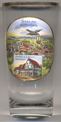
The picture on glass no. 4108 shows a panoramic view of Haiterbach and, in the bottom inset, the
"Gasthof zum Löwen" ("Lion Inn").
![[scale]](lineal.jpg)