
|
|
| DEUTSCHLAND | GERMANY |
| Bundesland: Baden-Württemberg | |
| Regierungsbezirk: Stuttgart | |
| Landkreis: Ostalbkreis |
map →

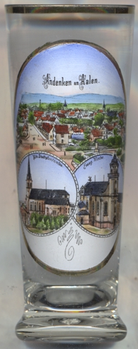
Aalen is situated at an elevation of 430 m in the upper Kocher valley of northeastern Baden-Württemberg, about 68 km east of Stuttgart. Aalen is the administrative centre of the district Ostalbkreis. The municipality has a population of about 68,400 (2021).
 The earliest traces of human settlements in this area date back to the Mesolithic period (8th to 5th century BC). The territory became part of the
Roman empire after AD 150. The Romans erected a castrum to house the cavalry unit Ala II Flavia milliaria, which presumably is the origin
of the modern name Aalen. Based on discovery of alamannic graves, archaeologists have established the 7th&nbs;century as the origination of Aalen.
The earliest written document that mentions Hamarstat (Hammerstadt, today part of Aalen), dates from 839; Alon was first mentioned in
ca. 1136. Documents from the Middle Ages indicate that the town of Aalen was founded by the Hohenstaufen some time between 1241 and 1246, but at
a different location than the earlier village, which was supposedly destroyed in 1388. Later, it is documented that the counts of Oettingen ruled the
town in 1340. They are reported to have pawned the town to the House of Württemberg in 1358 or 1359. In 1360, Aalen obtained the privileges of an
Imperial City, i.e. a city or town responsible only to the emperor, a status that made it a quasi-sovereign city-state and that it kept until 1803.
With the signing of the Treaty of Lunéville in 1801, which ended the War of the Second Coalition and which led to the
German Mediatisation of 1803 that assigned most Imperial Cities to the neighbouring principalities, Aalen was assigned to the electorate (1806 kingdom)
of Württemberg and was made a district town. Industrialisation only really started in 1861 when Aalen was connected to the Rems Railway leading from
Cannstadt (today part of Stuttgart) to Wasseralfingen. The Rems Railway's extension to Nördlingen (today called
Ries Railway) in 1863, the opening of the Brenz Railway (Aalen – Ulm) in 1864 and of the Upper Jagst Railway
(Goldshöfe (today part of Aalen) to Crailsheim) in 1866 turned Aalen into a railway hub. Fortunately, Aalen avoided most of the combat activity during
World War II. It was only during the last weeks of the war that Aalen became a target of air warfare, which led to the destruction and severe damage
of parts of the town. Aalen became part of the State of Baden-Württemberg, upon its creation in 1952. In 1973, the district of Aalen was merged with
the former district of Schwäbisch-Gmünd into the present Ostalbkreis district.
The earliest traces of human settlements in this area date back to the Mesolithic period (8th to 5th century BC). The territory became part of the
Roman empire after AD 150. The Romans erected a castrum to house the cavalry unit Ala II Flavia milliaria, which presumably is the origin
of the modern name Aalen. Based on discovery of alamannic graves, archaeologists have established the 7th&nbs;century as the origination of Aalen.
The earliest written document that mentions Hamarstat (Hammerstadt, today part of Aalen), dates from 839; Alon was first mentioned in
ca. 1136. Documents from the Middle Ages indicate that the town of Aalen was founded by the Hohenstaufen some time between 1241 and 1246, but at
a different location than the earlier village, which was supposedly destroyed in 1388. Later, it is documented that the counts of Oettingen ruled the
town in 1340. They are reported to have pawned the town to the House of Württemberg in 1358 or 1359. In 1360, Aalen obtained the privileges of an
Imperial City, i.e. a city or town responsible only to the emperor, a status that made it a quasi-sovereign city-state and that it kept until 1803.
With the signing of the Treaty of Lunéville in 1801, which ended the War of the Second Coalition and which led to the
German Mediatisation of 1803 that assigned most Imperial Cities to the neighbouring principalities, Aalen was assigned to the electorate (1806 kingdom)
of Württemberg and was made a district town. Industrialisation only really started in 1861 when Aalen was connected to the Rems Railway leading from
Cannstadt (today part of Stuttgart) to Wasseralfingen. The Rems Railway's extension to Nördlingen (today called
Ries Railway) in 1863, the opening of the Brenz Railway (Aalen – Ulm) in 1864 and of the Upper Jagst Railway
(Goldshöfe (today part of Aalen) to Crailsheim) in 1866 turned Aalen into a railway hub. Fortunately, Aalen avoided most of the combat activity during
World War II. It was only during the last weeks of the war that Aalen became a target of air warfare, which led to the destruction and severe damage
of parts of the town. Aalen became part of the State of Baden-Württemberg, upon its creation in 1952. In 1973, the district of Aalen was merged with
the former district of Schwäbisch-Gmünd into the present Ostalbkreis district.
The old, neo-Gothic, Catholic  parish church St. Maria was built in 1868. It was demolished in 1969 to make way for
the construction of the Hochbrücke bridge. A modern church building was erected nearby in 1972.
parish church St. Maria was built in 1868. It was demolished in 1969 to make way for
the construction of the Hochbrücke bridge. A modern church building was erected nearby in 1972.
The Protestant Stadtkirche [left, no. 4340: bottom right picture]
presumably is already the third church building at this site. A first, Catholic, parish church at this site, dedicated to St. Nicholas, already
had been mentioned in 1340. Aalen became Protestant in 1575. When a large fire had destroyed the previous church in 1634, the church was wuickly rebuilt
in 1648/1649. The tower was later heightened to 46 metres, but collapsed in 1765. After that, the church was completely rebuilt in 1765–1767
and is a rare example of a Protestant church in Baroque style. Although the church is still dedicated to St. Nicholas, it is usually only refered
to as Stadtkirche ('Town Church').
[https://de.wikipedia.org/wiki/Aalen, https://en.wikipedia.org/wiki/Aalen;
https://katholische-kirche-aalen.de/startseite/st-maria/, https://www.schwaebische.de/regional/ostalb/aalen/vor-40-jahren-ist-die-neue-marienkirche-geweiht-worden-911399;
https://de.wikipedia.org/wiki/Stadtkirche_Aalen]
![[scale]](lineal.jpg)