
|
|
| ČESKÁ REPUBLIKA | CZECH REPUBLIC |
| Plzeňský kraj | Plzeň region |
| Okres: Plzeň-jih |
map →
The first written mention of Přeštice is in a deed of King Otakar II from 1226, when it was referred to as a market village.
In 1239, the village was bought by the monastery in Kladruby. During the Hussite Wars (1419–1434), Přeštice was acquired by the
Švihovský z Rýzmberk family, who owned it for two centuries. In the early 19th century, Přeštice was badly damaged
by a large fire, but the town recovered. The construction of the road from Plzeň to Klatovy, which began to be built in
1809, contributed to the development of the town. In 1874, the Plzeň–Klatovy railway was put into operation. Until 1918, Prestitz (the
German name of Přeštice) was part of Austria-Hungary, in the district of the same name. After the breakup of the Austro-Hungarian
monarchy in 1918 and the creation of Czechoslovakia, the Czech name Přeštice became official. Only during the period of the
German occupation (1939–1945) the name was germanized again, this time in the form Pschestice.
[https://de.wikipedia.org/wiki/P%C5%99e%C5%A1tice, https://en.wikipedia.org/wiki/P%C5%99e%C5%A1tice;
https://de.wikipedia.org/wiki/Mari%C3%A4-Himmelfahrts-Kirche_(P%C5%99e%C5%A1tice)]
 Přeštice is situated at an elevation of 345 m on the river Úhlava, about 19 km south of the regional capital
Plzeň. The municipality has a population of about 6,800 (2023).
Přeštice is situated at an elevation of 345 m on the river Úhlava, about 19 km south of the regional capital
Plzeň. The municipality has a population of about 6,800 (2023).
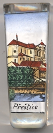
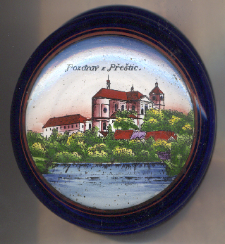
The  church of the Assumption of the Virgin Mary [left, no. 4442, and above,
no. 4958] is the main landmark of Přeštice. It was built in the Baroque style in place of an older, Gothic, church
in 1748–1775 and was designed by Kilian Ignaz Dientzenhofer and continued by Anselmo Lurago and Anton Haffenecker. The church remained
unfinished as the two towers were not built to their planned height. In 1855, the church was given a simpler roof, which was destroyed by a
lightning strike in 1892. Major restoration works ewre carried out on the neglected church in 1926–1928 and 1932–1937. During
anojer major restoration in 1993–1995, the two towers were completed in the form originaly designed by Dientzenhofer.
church of the Assumption of the Virgin Mary [left, no. 4442, and above,
no. 4958] is the main landmark of Přeštice. It was built in the Baroque style in place of an older, Gothic, church
in 1748–1775 and was designed by Kilian Ignaz Dientzenhofer and continued by Anselmo Lurago and Anton Haffenecker. The church remained
unfinished as the two towers were not built to their planned height. In 1855, the church was given a simpler roof, which was destroyed by a
lightning strike in 1892. Major restoration works ewre carried out on the neglected church in 1926–1928 and 1932–1937. During
anojer major restoration in 1993–1995, the two towers were completed in the form originaly designed by Dientzenhofer.
![[scale]](lineal.jpg) contact: webmaster
contact: webmaster