
|
|
| FRANCE | FRANCE |
| région: Auvergne-Rhône-Alpes | |
| département: 01, Ain |
map →
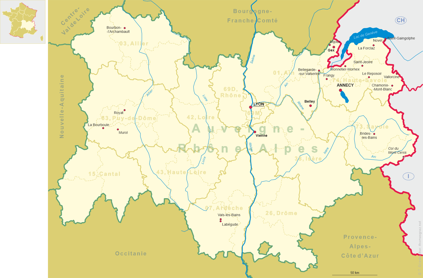
Bellegarde-sur-Valserine is situated at an elevation of 508 m at the confluence of the rivers Valserine and Rhône in the northeast of the département Ain, about 48 km southeast of the chef-lieu of the département, Bourg-en-Bresse, and about 85 km northeast of Lyon, the capital of the réion Auvergne-Rhône-Alpes. As of 2018, Bellegarde has a population of about 11,500. Since 2019 it is a Commune déléguée within the new municipality of Valserhône.
Even in Roman times, the area of today's Bellegarde at the Rhône crossing had important strategic importance. The crossing was
secured by a watchtower and there was probably a small settlement here. During the Middle Ages , Musinens developed into the main settlement
of today's municipal area on the heights northwest of the Bellegarde basin. Bellegarde, on the other hand, was just a small hamlet that
belonged to Musinens. However, this changed suddenly between 1853 and 1858 with the construction of the railway line from Lyon to
Geneva, which ran along the Rhône through the Bellegarde basin. In 1858, the community of Musinens was
renamed Bellegarde. Together with the establishment of the factories, the former hamlet quickly developed into an industrial town
 with numerous workers' apartments. As the last train station in France before Geneva's free trade zone , which has existed since 1815,
Bellegarde was also a customs station. With the completion of the Génissiat dam and the damming of the Rhône in 1948, a major
tourist attraction, the Rhône seepage (see below), was flooded, resulting in a marked decline in tourism revenue. The municipality's name was
officially changed to Bellegarde-sur-Valserine in 1956. In 2019 Bellegarde-sur-Valserine was merged with Châtillon-en-Michaille
and Lancransinto into the new municipality of Valsrhône. The former municipalities today have the status of Communes
déléguées. Bellegarde has remained the seat of the administration of the new municipality.
with numerous workers' apartments. As the last train station in France before Geneva's free trade zone , which has existed since 1815,
Bellegarde was also a customs station. With the completion of the Génissiat dam and the damming of the Rhône in 1948, a major
tourist attraction, the Rhône seepage (see below), was flooded, resulting in a marked decline in tourism revenue. The municipality's name was
officially changed to Bellegarde-sur-Valserine in 1956. In 2019 Bellegarde-sur-Valserine was merged with Châtillon-en-Michaille
and Lancransinto into the new municipality of Valsrhône. The former municipalities today have the status of Communes
déléguées. Bellegarde has remained the seat of the administration of the new municipality.
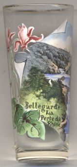
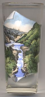
 La perte du Rhône (the Rhône seepage) [left, no. 4474] was perhaps the major
tourist attraction of Bellegarde. At this site, a sixty-metre-deep geologic fault just upstream of Bellegarde-sur-Valserine caused the
Rhône river to disappear during the dry season. It marked the border between the départements Ain and Haute-Savoie. In 1948, the
Génissiat Dam, designed by French architects Albert Laprade and Léon Bazin, was built to the south of Bellegarde. With the
construction of the dam, the Perte du Rhône was transformed into a reservoir twenty three kilometres long, from Génissiat to the
Swiss border. A similar feature called Pertes de la Valserine still exists in the same area.
La perte du Rhône (the Rhône seepage) [left, no. 4474] was perhaps the major
tourist attraction of Bellegarde. At this site, a sixty-metre-deep geologic fault just upstream of Bellegarde-sur-Valserine caused the
Rhône river to disappear during the dry season. It marked the border between the départements Ain and Haute-Savoie. In 1948, the
Génissiat Dam, designed by French architects Albert Laprade and Léon Bazin, was built to the south of Bellegarde. With the
construction of the dam, the Perte du Rhône was transformed into a reservoir twenty three kilometres long, from Génissiat to the
Swiss border. A similar feature called Pertes de la Valserine still exists in the same area.
Glass no. 4474 is marked on the bottom Importé d'Autriche.
[https://de.wikipedia.org/wiki/Bellegarde-sur-Valserine, https://en.wikipedia.org/wiki/Bellegarde-sur-Valserine, https://fr.wikipedia.org/wiki/Bellegarde-sur-Valserine;
https://en.wikipedia.org/wiki/Perte_du_Rh%C3%B4ne;
http://fallingrain.com/world/FR/B9/BellegardesurValserine.html]
![[scale]](lineal.jpg)