
|
|
| ČESKÁ REPUBLIKA | CZECH REPUBLIC |
| Královéhradecký kraj | Hradec Králové region |
| Okres: Trutnov |
map →
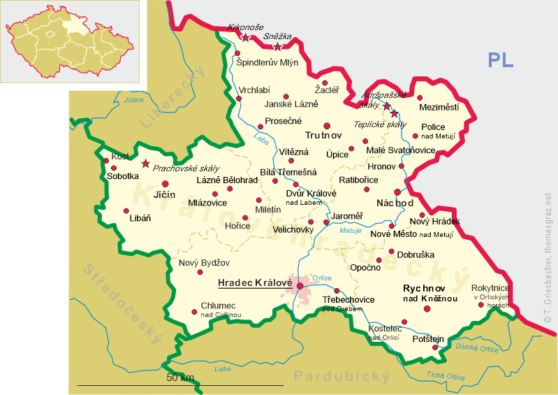
 Vítězná is situated at an elevation 498 m in the foothills of the Giant Mountains (Krkonoše) of northeastern Bohemia,
about 12 km southwest of the district town Trutnov and about 31 km north of the regional capital,
Hradec Králové. The municipality has a population of about 1,500 (2023) and consists of the localities Bukovina (former name
in German: Bukowina), Hájemství (Hegerbusch), Huntířov (Güntersdorf), Kocléřov (Ketzelsdorf), Komárov (Komar,
Kommar), Nové Záboří (Neu Söberle, Neukränke) and Záboří (Söberle).
Vítězná is situated at an elevation 498 m in the foothills of the Giant Mountains (Krkonoše) of northeastern Bohemia,
about 12 km southwest of the district town Trutnov and about 31 km north of the regional capital,
Hradec Králové. The municipality has a population of about 1,500 (2023) and consists of the localities Bukovina (former name
in German: Bukowina), Hájemství (Hegerbusch), Huntířov (Güntersdorf), Kocléřov (Ketzelsdorf), Komárov (Komar,
Kommar), Nové Záboří (Neu Söberle, Neukränke) and Záboří (Söberle).
The oldest part of the municipality is Kocléřov (Ketzelsdorf) which was probably founded at the beginning of the 14th century and which was first mentioned in a written document in 1360 (Koclerstorf). After the end of manorialism in the mid-19th century, the villages Weiberkränke, Neu Rettendorf, Neu Koken and Neu Söberle formed the municipality of Königreich I/Království I, Hegerbusch and Oberdöberney formed the municipality of Königreich II/Království II. After World War II, the German-speaking majority of the population was expelled. In 1961, the municipalities of Hájemství, Huntířov (including the village of Bukovina), Kocléřov, Komárov and Záboří (including the village of Nové Záboří) were merged to form the current municipality of Vítězná.
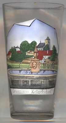
The  church of St. Wenceslas in Kocléřov [left, no. 4492] was built in Baroque style in 1720
and rebuilt in 1807. It was built on the site of an old Gothic church that had been built here in 1359.
church of St. Wenceslas in Kocléřov [left, no. 4492] was built in Baroque style in 1720
and rebuilt in 1807. It was built on the site of an old Gothic church that had been built here in 1359.
[https://de.wikipedia.org/wiki/V%C3%ADt%C4%9Bzn%C3%A1, https://en.wikipedia.org/wiki/V%C3%ADt%C4%9Bzn%C3%A1, https://cs.wikipedia.org/wiki/V%C3%ADt%C4%9Bzn%C3%A1]
![[scale]](lineal.jpg)