
|
|
| ČESKÁ REPUBLIKA | CZECH REPUBLIC |
| Pardubický kraj | Pardubice region |
| Okres: Ústí nad Orlicí |
map →
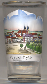
 Vysoké Mýto is situated at an elevation of 289 m in East Bohemia. The town was founded in 1262 on a trading path that connected Bohemia with Moravia.
Since 1307 it was a dowry town of the Czech queens. The ground plan of the town with its rectangular blocks of houses and a large central square
is an important relic of town Gothic architecture. The main square is the largest square in Bohemia. At the beginning of the 19th century Vysoké Mýto was
the seventh largest town in the kingdom of Bohemia.
Vysoké Mýto is situated at an elevation of 289 m in East Bohemia. The town was founded in 1262 on a trading path that connected Bohemia with Moravia.
Since 1307 it was a dowry town of the Czech queens. The ground plan of the town with its rectangular blocks of houses and a large central square
is an important relic of town Gothic architecture. The main square is the largest square in Bohemia. At the beginning of the 19th century Vysoké Mýto was
the seventh largest town in the kingdom of Bohemia.
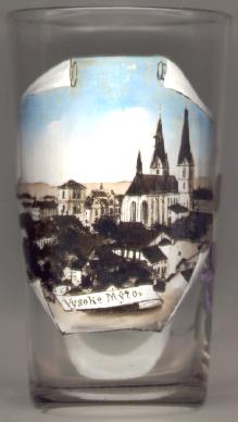
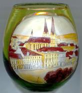
The  cathedral Sv. Vavřinec (St. Laurentius) [near left, no. 454: centre right] dates back to the 13th century.
It was first mentioned in a document of 1349. The Gothic vaulting was completed in 1525.
The altarpiece on the main altar dates from 1728. The altar originally stood in the church of the Cistercian monastery of Sedlec
(today part of Kutná Hora) and was
brought to St. Vavřinec cathedral in 1787.
cathedral Sv. Vavřinec (St. Laurentius) [near left, no. 454: centre right] dates back to the 13th century.
It was first mentioned in a document of 1349. The Gothic vaulting was completed in 1525.
The altarpiece on the main altar dates from 1728. The altar originally stood in the church of the Cistercian monastery of Sedlec
(today part of Kutná Hora) and was
brought to St. Vavřinec cathedral in 1787.
The bell tower [near left, no. 454: left] was built in 1582–1585. A second floor for smaller bells was added in 1720.
The bells were moved to the towers of the cathedral in 1899. After a renovation in 1985–1989 the tower is now used as an exhibition place of the town's art collections.
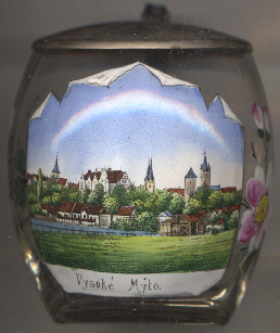
The Sokolovna [near left, no. 4949: background centre], a gymnasium
building for the Czech Sokol movement, was built in 1900–1902 by the architect Josef Podhajský in the
Art Nouveau style.
[https://www.sokolskepamatky.eu/objekty/detail/sokolovna-vysoke-myto]
![[scale]](lineal.jpg)