
|
|
| ÖSTERREICH | AUSTRIA |
| Bundesland: Steiermark | Styria |
| Bezirk: Murtal |
map →

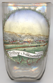 Zeltweg is situated at an elevation of 659 m on the left bak of the river Mur in the north-Styrian district Murtal
(combined in 2012 from the former districts Judenburg and Knittelfeld), about
8 km northeast of Judenburg, and about 54 km northwest of the capital of Austria's state of Styria,
Graz. The municipality has a population of about 7,100 (2024).
Zeltweg is situated at an elevation of 659 m on the left bak of the river Mur in the north-Styrian district Murtal
(combined in 2012 from the former districts Judenburg and Knittelfeld), about
8 km northeast of Judenburg, and about 54 km northwest of the capital of Austria's state of Styria,
Graz. The municipality has a population of about 7,100 (2024).
Some farms were recorded at Zeltweg in the Duchy of Styria already during the 13th century. The village then was called Celtwich, its name is recorded in 1430 for the first time. Rafting of timber down the river was initiated in 1569 and thereafter gained considerable importance for the town's history. This Industrial Revolution brought a boom for Zeltweg. A railway station was built in 1868. Zeltweg was detached from neighboring Fohnsdorf as a municipality in its own right in 1875. In 1966, Zeltweg obtained the official status of a town.
The Zeltweg Airfield was used as a racing circuit in the 1960s and hosted the Formula One Grand Prix in 1964. The track was
abandoned in 1969 with the construction of the Österreichring, a purpose-built motorsport track in the neighbouring Spielberg.
[https://de.wikipedia.org/wiki/Zeltweg]
![[scale]](lineal.jpg)