
|
|
| POLSKA | POLAND |
| województwo: Lubuskie | voivodship: Lebus |
| powiat: Gorzów Wielkoposki | county: Gorzów Wielkoposki |
map →
Kostrzyn nad Odrą (German: Küstrin, until 1928 Cüstrin; Poish until 2003 Kostrzyn) is situated at an elevation of 10 m at the confluence of the rivers Warta (Warthe) and Odra (Oder), which here since 1945 marks the border between Poland and Germany. The town lies about 43 km southwest of Gorzów Wielkopolski, one of the two capitals of the Lebus voivodship. The municipality has a population of about 17,700 (2020). Until the end of World War II and the implementation of the Oder–Neisse line in 1945, the municipal area also comprised the Küstrin-Kietz suburb on the west bank of the Oder river, which today is part of the German Küstriner Vorland municipality. The former town centre, the Kostrzyn fortress located on the headland between the Oder and Warta rivers, was destroyed by the Red Army as an act of revenge weeks before the end of the war and not rebuilt. Today Kostrzyn's central area is located around Kostrzyn railway station east of the Warta's mouth.
Settled since the Bronze Age, the area was held by the Piast dukes and kings of Poland from about 960 until 1261. In 1223 the fortress was granted to the Knights Templar. Cozsterine was first mentioned in a written document in 1232. In the 12th century it developed into a fortified castellany and a Polish taxation post, however, together with Lubusz Land it was seized by the Ascanian margraves of Brandenburg in 1261 and incorporated into their Neumark territory east of the Oder river. By 1300 the town had received Magdeburg town rights and started to grow rapidly, owing largely to trade on the rivers. From 1319 there was a dispute over the town between the Piasts, the Griffins and the Ascanians, and there were heavy fights between the Duchy of Pomerania and the Duchy of Saxe-Wittenberg in the area in 1322–1323. A peace treaty between Pomerania and Saxe-Wittenberg was signed in the town in 1323. In 1373 the town became part of the Lands of the Bohemian Crown, ruled by the Luxembourg dynasty. In 1402, the Luxembourgs reached an agreement with Poland in Kraków, under which Poland was to buy and reincorporate Kostrzyn and the surrounding region, but eventually the Luxembourgs sold the town to the Teutonic Order. After the Thirteen Years’ War broke out in 1454, the Teutonic Knights sold the town to Brandenburg in order to raise funds for war against Poland. Between 1535 and 1571 the town was the seat of Johann of Brandenburg-Küstrin, who made it the capital of the Neumark region and built a castle. With time this castle was expanded into a fortress, one of the largest such facilities in the region. While still crown prince, Frederick the Great was imprisoned in the fortress, from which he witnessed the execution of his friend Hans Hermann von Katte on 6 November 1730. Captured by the French in 1806, Küstrin was occupied by a French military garrison for the remainder of the Napoleonic Wars. During the French retreat from the east in 1814, the town was set on fire and burnt to the ground. The town recovered and became one of the most important railway hubs in the Kingdom of Prussia and later the German Empire. During World War II, due to Allied air raids on the railway hub and local factories and its position as a German bridgehead on the east bank of the Oder during the Battle of the Oder–Neisse and the Battle of the Seelow Heights, almost 95% of its buildings were destroyed and the town was generally deserted. After the war the ruined town became part of Poland again by decision of the Potsdam Conference; Germans remaining in the town were expelled in accordance with the Potsdam Agreement.
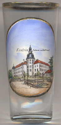
 Küstrin castle was the most important castle building in the historical Neumark region. The medieval castle, first
mentioned in 1323, was built about 50 metres from the banks of the Oder river. The castle depicted on glass no. 4817 [left]
was originally built by the Teutonic order between 1444 and 1452. In a second medieval construction phase, a newer three-story wing was built north of the
Oder wing. At the same time, the Oder wing was raised by one storey. In 1455, the margraves of Brandenburg came in possession of the region. When the
margraviate was divided in 1535, the castle became the residence of Margrave Johann of Brandenburg-Küstrin until his death in 1571. Johann had the
castle rebuilt into a representative Renaissance palace in the late 1530s. The reversion of the Neumark to the Electors in 1571 marked the end of the
palace's role as a residence. From then on, it served as a fortress commandant's office, administrative building, and prison. In the later 18th century,
the castle also served as a barracks, and from the 19th century onwards, exclusively as a barracks. The castle was destroyed together with the old
town centre during the Battle of Kostrzyn in 1945. The ruins were removed for building materials and leveled in 1969. Today, the overgrown foundations of
the castle and town are one of the attractions of the "Küstrin Pompeii", while the fortifications are gradually being restored and are open to visitors.
Küstrin castle was the most important castle building in the historical Neumark region. The medieval castle, first
mentioned in 1323, was built about 50 metres from the banks of the Oder river. The castle depicted on glass no. 4817 [left]
was originally built by the Teutonic order between 1444 and 1452. In a second medieval construction phase, a newer three-story wing was built north of the
Oder wing. At the same time, the Oder wing was raised by one storey. In 1455, the margraves of Brandenburg came in possession of the region. When the
margraviate was divided in 1535, the castle became the residence of Margrave Johann of Brandenburg-Küstrin until his death in 1571. Johann had the
castle rebuilt into a representative Renaissance palace in the late 1530s. The reversion of the Neumark to the Electors in 1571 marked the end of the
palace's role as a residence. From then on, it served as a fortress commandant's office, administrative building, and prison. In the later 18th century,
the castle also served as a barracks, and from the 19th century onwards, exclusively as a barracks. The castle was destroyed together with the old
town centre during the Battle of Kostrzyn in 1945. The ruins were removed for building materials and leveled in 1969. Today, the overgrown foundations of
the castle and town are one of the attractions of the "Küstrin Pompeii", while the fortifications are gradually being restored and are open to visitors.
[https://de.wikipedia.org/wiki/Kostrzyn_nad_Odr%C4%85, https://en.wikipedia.org/wiki/Kostrzyn_nad_Odr%C4%85;
https://de.wikipedia.org/wiki/Schloss_K%C3%BCstrin]
![[scale]](lineal.jpg)