
|
|
| ÖSTERREICH | AUSTRIA |
| Bundesland: Niederösterreich | Lower Austria |
| Bezirk: Tulln |
map →

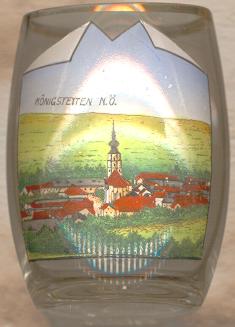 Königstetten is situated at an elevation of 181 m on the foot of the Tulbingerkogel (494 m) at the northern end of the Wienerwald region.
The first mentioning in a document dates from AD 985 Königstetten obtained the status of a market town in 1438.
Königstetten is situated at an elevation of 181 m on the foot of the Tulbingerkogel (494 m) at the northern end of the Wienerwald region.
The first mentioning in a document dates from AD 985 Königstetten obtained the status of a market town in 1438.
The  parish church Sankt Jakobus der ältere (St. James the Greater) was built 1382–1415 in Gothic style and was remodelled in Early Baroque style in 1687.
![[scale]](lineal.jpg)