
|
|
| ÖSTERREICH | AUSTRIA |
| Bundesland: Kärnten | Carinthia |
| Bezirk: Spittal an der Drau |
map →
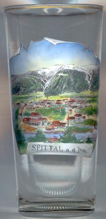 Spittal an der Drau is situated at an elevation of 560 m on the river Drau
at the mouth of the river Lieser. The origin of the town dates back to 1191 when
a hospital was founded here by the Counts of Ortenburg (which is also the origin of the name).
Since 1242 it had the status of a market town.
In 1478 the town was destroyed by the Turks and rebuilt by the Counts of Ortenburg
and the Princes of Porcia.
In 1797 it was destroyed by French troops.
Spittal obtained the status of a town in 1930.
Spittal an der Drau is situated at an elevation of 560 m on the river Drau
at the mouth of the river Lieser. The origin of the town dates back to 1191 when
a hospital was founded here by the Counts of Ortenburg (which is also the origin of the name).
Since 1242 it had the status of a market town.
In 1478 the town was destroyed by the Turks and rebuilt by the Counts of Ortenburg
and the Princes of Porcia.
In 1797 it was destroyed by French troops.
Spittal obtained the status of a town in 1930.
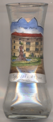
 Schloss Porcia (or Schloss Salamanca)
[left, no. 4033, and right, no. 532: background centre] at the far end of the main square
was built 1533–1597 for Gabriel von Salamanca (Count of Ortenburg since 1524).
It is one of Austria's most beautiful palaces in Italian Renaissance style.
From 1662 until 1915 it was in possession of the Princes of Porcia.
(Note: on the glass the palace is labeled Schloss Portia, which, like Porzia, was an alternative spelling used in the past.)
Schloss Porcia (or Schloss Salamanca)
[left, no. 4033, and right, no. 532: background centre] at the far end of the main square
was built 1533–1597 for Gabriel von Salamanca (Count of Ortenburg since 1524).
It is one of Austria's most beautiful palaces in Italian Renaissance style.
From 1662 until 1915 it was in possession of the Princes of Porcia.
(Note: on the glass the palace is labeled Schloss Portia, which, like Porzia, was an alternative spelling used in the past.)
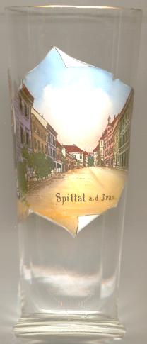
Other glasses of this collection show views from Spital am Pyhrn.
![[scale]](lineal.jpg)