
|
|
| ÖSTERREICH | AUSTRIA |
| Bundesland: Steiermark | Styria |
| Bezirk: Voitsberg |
map →

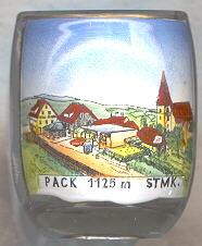 The village of Pack is situated a few km north
of the Packsattel (1,169 m), the highest point of the road connecting western Styria with Carinthia.
On 1 January, the former independent municipalities of Hirschegg and Pack were merged to become the
new municipality of Hirschegg-Pack.
The village of Pack is situated a few km north
of the Packsattel (1,169 m), the highest point of the road connecting western Styria with Carinthia.
On 1 January, the former independent municipalities of Hirschegg and Pack were merged to become the
new municipality of Hirschegg-Pack.
The  parish church of St. Martin was first mentioned in 1245. The church of today
was built after the demolition of the old church by the Turks in 1480. The tower dates from 1524.
Church and tower received their current appearance in Baroque style between 1766 and 1770.
parish church of St. Martin was first mentioned in 1245. The church of today
was built after the demolition of the old church by the Turks in 1480. The tower dates from 1524.
Church and tower received their current appearance in Baroque style between 1766 and 1770.
![[scale]](lineal.jpg)