
|
|
| MAGYARORSZÁG | HUNGARY |
| megye: Győr-Moson-Sopron |
map →
There are only few towns in Hungary that have preserved their old town as perfectly as Sopron. Most buildings received their shape in the Middle Ages and in the Baroque. In 1972 the town was awarded the European Prize for Protection of Monuments.
Situated on the Amber Road conecting the Baltic Sea with Italy, the place was already an important trading place even before the Romans conquered Pannonia. In the 2nd Century AD the Roman Scarbantia was already an important town with capitol, forum and fortifications. The 4th Century brought religious freedom for the Christians of the area. In 1277 the town was granted the status of a free royal town. The fortifications of 1297–1339 stood the time of the Turkish invasions and are still partly preserved today. The town was almost completely destroyed by fire in 1676 and was restored thereafter in Baroque style.
After World War I and the Treaty of Paris / Trianon (1920) the German-speaking population of the Western parts of the Kingdom of
Hungary decided in a referendum in 1921 to join Austria, forming Austria's ninth federal state, Burgenland.
However, the town of Sopron decided to stay in Hungary. The Hungarian government therefore
granted the town the title urbs fedilissima (most faithful town).
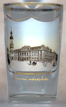
The  Town Hall [left, no. 593: centre] (hung: Városháza)
was completed in 1896 to commemorate the millenium of the arrival of the first Hungarians in the
Carpathian Basin (896).
Town Hall [left, no. 593: centre] (hung: Városháza)
was completed in 1896 to commemorate the millenium of the arrival of the first Hungarians in the
Carpathian Basin (896).
The City Tower (hung: Várostorony) [left, no. 593: background left], also called Fire Tower
(hung: Tűztorony), at the Northern edge of
the old town is the landmark of Sopron. Its foundations date from the Roman times.
The lower, rectangular part was erected in the 14th century. The middle, cylindrical part
was added in the Renaissance. The tower was completed with the upper part, a clock tower,
in 1681/82. The total height of the tower is 61 m. [The picture on no. 593:left shows the old
large open archway of the City Tower which was replaced in 1928 by the Fidelity Gate.
See right, no. 587]
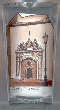
After the referendum of 1921 the Fidelity Gate [right, no. 587]
in the City Tower was presented to the city by the Hungarian government in 1928. The relief represents the citizens of Sopron
paying homage to the mythological figure of Hungaria.
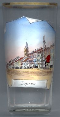
The Várkerület (city ring, German: Grabenrunde) [left, no. 1615]
was created after the town's fortifications were torn down and the moats were filled. The outer row of houses dates back to
the Middle Ages, while the inner row of houses was created in the Baroque, Rococo and Historicist periods.
The Lady column (Mária-oszbor) [left, no. 1615: right]
was created in 1745 by the sculptor Jakob Schletterer according to a design by the architect Andrea Altomonte. The column stands at the site
of the medieval Lady church which had been torn down at the time of the the Turkish siege of Kőszeg in 1632
because the citizens feared that the invading Turks would use the church tower to bombard the city.
The church of St. George (Szent György templom) [left, no. 1615: background]
was built in the 14th and 15th centuries. The interior decorations date from the Baroque period.
![[scale]](lineal.jpg)