
|
|
| ČESKÁ REPUBLIKA | CZECH REPUBLIC |
| Jihomoravský kraj | South Moravia (Brno) region |
| Okres: Břeclav |
map →
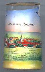 Hustopeče (German: Auspitz) was first mentioned as a village in 1247.
Its location on the so-called Hungarian Road, a trading route from Moravia to Hungary,
was important for the development of the place. In 1350 it obtained the status
of a market town, and in 1572 that of a town. After 1528 the Moravian Anabaptists
settled here. The Anabaptists and the Bohemian Brethren disappeared at the beginning
of the 17th century. During the Nazi administration between 1938 and 1945 the
region of Hustopeče/Auspitz was part of Lower Austria (then Gau Niederdonau).
Hustopeče (German: Auspitz) was first mentioned as a village in 1247.
Its location on the so-called Hungarian Road, a trading route from Moravia to Hungary,
was important for the development of the place. In 1350 it obtained the status
of a market town, and in 1572 that of a town. After 1528 the Moravian Anabaptists
settled here. The Anabaptists and the Bohemian Brethren disappeared at the beginning
of the 17th century. During the Nazi administration between 1938 and 1945 the
region of Hustopeče/Auspitz was part of Lower Austria (then Gau Niederdonau).
 The
The  church Svatý Václáv (St. Wenceslas, Duke Wenceslaus I of Bohemia) [far left, barely visible]
dates back to the 13th century. In 1961 the spire of the church collapsed onto the roof of the nave. Subsequently,
the ruins of the old church were cleared away and a new, modern, church (Kostel sv. Václava a sv. Anežky České,
St. Wenceslas and St. Agnes of Bohemia) was built in place of the old one.
The parsonage of the old church is the setting of one of the scenes
of the book Der veruntreute Himmel (Embezzled Heaven) of the
famous Austrian writer Franz Werfel (1890–1945).
church Svatý Václáv (St. Wenceslas, Duke Wenceslaus I of Bohemia) [far left, barely visible]
dates back to the 13th century. In 1961 the spire of the church collapsed onto the roof of the nave. Subsequently,
the ruins of the old church were cleared away and a new, modern, church (Kostel sv. Václava a sv. Anežky České,
St. Wenceslas and St. Agnes of Bohemia) was built in place of the old one.
The parsonage of the old church is the setting of one of the scenes
of the book Der veruntreute Himmel (Embezzled Heaven) of the
famous Austrian writer Franz Werfel (1890–1945).
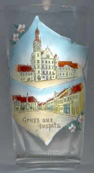
The town hall [right, no. 1521: top]
was built in 1906 in Neo-Renaissance style.
The Baroque Trinity Column (also called Plague Column)
[right, no. 1521: bottom, left] was erected in 1688.
Tomáš Garrigue MASARYK (1850–1937), the first President (1918–1935)
of Czechoslovakia, went to school in Hustopeče.
![[scale]](lineal.jpg)