
|
|
| ÖSTERREICH | AUSTRIA |
| Bundesland: Steiermark | Styria |
| Bezirk: Deutschlandsberg |
map →

Bad Schwanberg is situated at an elevation of 427 m on the river Schwarze Sulm about 7 km south of the district town Deutschlandsberg and about 39 km southwest of the capital of Styria, Graz. The municipality has a population of about 4,400 (2024).
Archeological finds demonstrate that the area had alreeady been inhabited in Roman times. A first stronghold was founded around 880, which in the 10th century was replaced by a castle. In 1056 the domains came in possession of the bishops of Brixen/Bressanone, followed in the 13th century by the lords of Pettau (Ptuj). The name Suanberch was first mentioned in 1243. In 1363 the village was first mentioned as a market town, but it is assumed that it gained this privilege already in the late 13th or early 14th century. In the mid-15th century, Schwanberg came in possession of the Habsburg Emperor, but the bishops of Brixen contended this until the mid-17th century. Around 1580 the old castle was demolished and the new castle was built using material of the old one. The domains passsed to the counts Saurau in 1647, and in 1822 they were sold to the princes of Liechtenstein (see Vaduz). The castle was sold to the duchy of Styria in 1891. The neighbouring community of Mainsdorf was incorporated into Schwanberg in 1969, the municipalities of Garanas, Gressenberg and Hollenegg followed in 2015. In 2020 the predicate Bad was added to the name of the municipality.
 The
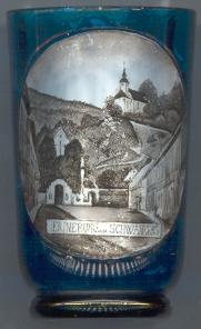
The  monastery of the Capuchins
[bottom left] was founded in 1706. The monastery church
Heiliger Schutzengel (Guardian Angel), consecrated in 1714, was built
following the example of the church of the Capuchins in Graz. The monastery
existed until 1969. In 1971–1973 its buildings were adapted for the use as a
mud-bath spa.
monastery of the Capuchins
[bottom left] was founded in 1706. The monastery church
Heiliger Schutzengel (Guardian Angel), consecrated in 1714, was built
following the example of the church of the Capuchins in Graz. The monastery
existed until 1969. In 1971–1973 its buildings were adapted for the use as a
mud-bath spa.
The filial church Sankt Joseph
[top right] on the hill above the market was erected in 1685.
It contains frescos from 1955–1960 and 1981 depicting the legend of Saint Joseph.
[https://de.wikipedia.org/wiki/Bad_Schwanberg;
https://www.schwanberg.gv.at/historisches/herrschaft-altburg-schwanberg/, https://www.schwanberg.gv.at/historisches/markt-schwanberg/]
![[scale]](lineal.jpg)