
|
|
| DEUTSCHLAND | GERMANY |
| Bundesland: Freistaat Sachsen | Saxony |
| Landkreis: Vogtlandkreis |
map →

The
Elsterberga
Елстерберг
Ельстерберг
Эльстерберг
Эльстэрберг
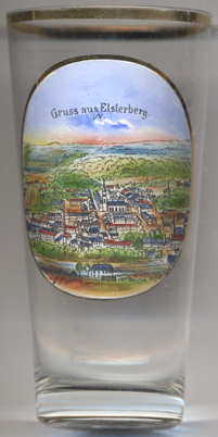 Elsterberg is situated on the river Elster in the district Vogtlandkreis in Western Saxony.
Elsterberg was first mentioned in a document in 1198. The earliest mention of its status of a town occurred in 1354.
The theologian and radical reformer Thomas Müntzer (ca.1490–1525) visited Elsterberg several times in 1520/21.
Like most other towns Elsterberg was also destroyed several times by large fires, the last time in 1840.
The regulation of the river Elster in 1934–1938 reduced the danger of floodings which had caused severe damages several times before, notably in 1799.
Following the administrative reform of 1952, Elsterberg became part of the district Gera in Thuringia. Following a referendum
in 1992, the town became part of the state of Saxony again.
Elsterberg is situated on the river Elster in the district Vogtlandkreis in Western Saxony.
Elsterberg was first mentioned in a document in 1198. The earliest mention of its status of a town occurred in 1354.
The theologian and radical reformer Thomas Müntzer (ca.1490–1525) visited Elsterberg several times in 1520/21.
Like most other towns Elsterberg was also destroyed several times by large fires, the last time in 1840.
The regulation of the river Elster in 1934–1938 reduced the danger of floodings which had caused severe damages several times before, notably in 1799.
Following the administrative reform of 1952, Elsterberg became part of the district Gera in Thuringia. Following a referendum
in 1992, the town became part of the state of Saxony again.
 church of Sankt Laurentius [left, no. 4586: centre] was built in 1841–1845 in
Historistic neo-Gothic style.
church of Sankt Laurentius [left, no. 4586: centre] was built in 1841–1845 in
Historistic neo-Gothic style.
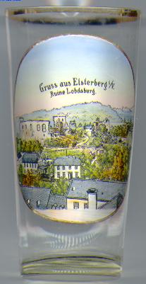
One of the tourist attractions of Elsterberg are the ruins of castle Elsterberg [near left, no. 758: background left].
The castle was erected prior to 1225 by the Lords of Lobdeburg. (The painting on the glass refers to the castle as 'Lobdaburg', a name which is not
used today as it can lead to confusion with the ruins of castle Lobdeburg near Jena.) Castle Elsterberg was conquered by
Emperor Karl IV during the Vogtland War of 1354–1358. Until 1366 the castle was enlarged and received 5 towers and a
double ring-wall. The castle ruins cover an area of more than 1.5 hectare and thus are one of the largest of their kind in Saxony.
![[scale]](lineal.jpg) contact: webmaster
contact: webmaster