|
|
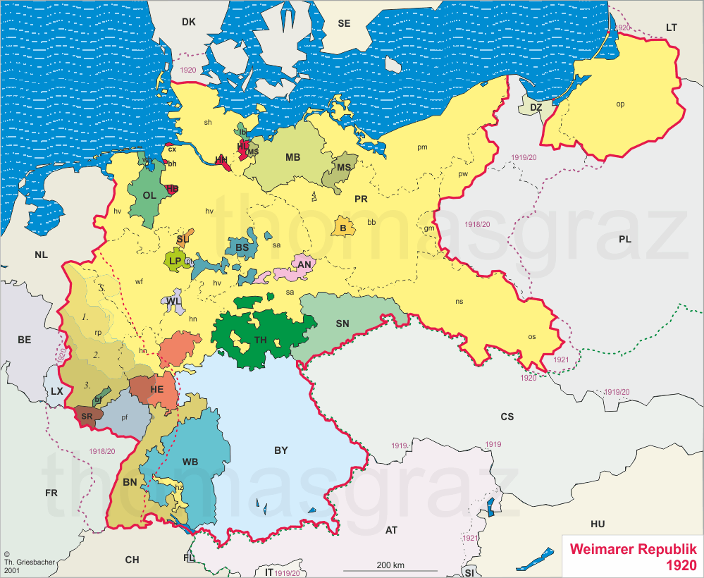
| Germany, Weimar Republic 1920 |
The dashed red line shows the eastern limit of the demilitarized zone.
The dashed purple line shows the border of the German Empire 1871–1918.
The dashed green line shows the border of the Austro-Hungarian Monarchy in 1918.
AN: Anhalt
|
B: Berlin
|
BN: Baden
|
BS: Braunschweig
|
BY: Bayern Bavaria:
|
HB: Freie Hansestadt Bremen Free Hanseatic Town Bremen:
bh Bremerhaven
|
HE: Hessen Hesse |
HH: Freie und Hansestadt Hamburg Free and Hanseatic Town Hamburg: cx Cuxhaven (1937 to Prussia)
|
HL: Freie und Hansestadt Lübeck Free and Hanseatic Town Lübeck: 1937 to Prussia
|
OL: Oldenburg: bf Fürstentum Birkenfeld (to Prussia in 1937); lb Fürstentum Lübeck (to Prussia in 1937)
|
MB: Mecklenburg-Schwerin: united with Mecklenburg-Strelitz to Mecklenburg in 1934
|
MS: Mecklenburg-Strelitz: united with Mecklenburg-Schwerin to Mecklenburg in 1934
|
PR:
Preußen Prussia:
|
SL: Schaumburg-Lippe
|
SN: Sachsen Saxony
|
SR: Saargebiet Saar Region: 1920–1935 under the League of Nations
|
TH: Thüringen Thuringia |
WB: Württemberg
|
WL: Waldeck: pt Pyrmont (1922 to Prussia; remaining part of Waldeck to Prussia in 1929)
|
S: sanctions 1920–1925; occupied by France 1923–1925
|
1: occupied until 1926
|
2: occupied until 1929
|
3: occupied until 1930
| |
The dashed red line shows the eastern limit of the demilitarized zone.
The dashed purple line shows the border of the German Empire 1871–1918.
The dashed green line shows the border of the Austro-Hungarian Monarchy in 1918.