
|
|
| ÖSTERREICH | AUSTRIA |
| Bundesland: Oberösterreich | Upper Austria |
| Stadt: Linz |
map →
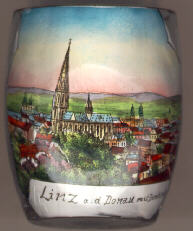
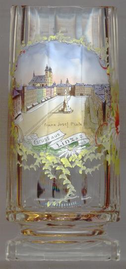 Linz is situated at an elevation of 266 m on the river Danube where the river enters the Linz plains.
The capital of Austria's state of Upper Austria has a population of about 210,000 inhabitants (2023). The name
Linz an der Donau is not official, but is frequently used to distinguish the town from Linz am Rhein in Germany.
Linz is situated at an elevation of 266 m on the river Danube where the river enters the Linz plains.
The capital of Austria's state of Upper Austria has a population of about 210,000 inhabitants (2023). The name
Linz an der Donau is not official, but is frequently used to distinguish the town from Linz am Rhein in Germany.
The earliest traces of continuous human habitation in this area date back to the Neolithic times.
During the second half of the 1st century AD the Romans founded a fort and a civil settlement.
Its name, Lentia, was derived from the Celtic word lentos, which means 'crooked' or 'bent' and
referred to the location at a river bend. The earliest mention of Linze is found in a document of 799
which referred to the church of St. Martin that still exists today. In about 1205/1206 the place
came in possession of the Babenberg dynasty. During the first half of the 13th century, Linz
had obtained the status of a town. Towards the end of the 13th century the town became the seat of the
administration of Upper Austria. Under the Habsburgs, Linz enjoyed the status of a residence town under
Duke Albrecht VI (1458–1463) and Emperor Friedrich III (1484/1485 and 1489–1493).
During the Austrian War of Succession (1741/1742) and the Napoleonic Wars (1800/1801, 1805/1806 and 1809)
the town was occupied several times by Bavarian and French troops.
Since the Middle Ages Linz was an important trading town. The first manufactures of Austria
were opened here in 1672. The 19th century brought further boosts for the industry. The horse-drawn railway between
Linz and Budweis (České Budějovice, CZ) was built in 1825–1832,
the line between Linz and Gmunden was completed in 1842.
The railroad was the first one in continental Europe, but was closed in 1872 after new lines for steam engines
had been built. Steam ships began to operate on the Danube in 1837/1838. After the industrialisation of the late 19th century
the town expanded and several of the surrounding municipalities were incorporated in the city.
Austria's Civil War of 1934 began here in Linz. During the Nazi era, the town became a war industry centre of the Third Reich.
Consequently, the town was severly hit by 22 Allied bomb raids during World War II in 1944 and 1945.
Between 1945 and 1955 the Danube marked the demarkation line between the Russian zone in the north and
the American zone in the south. Urfahr, which had been incorporated into the city of Linz in 1919,
was an independent town again during this period and was the seat of the Soviet administration.
Together with Vilnius (Lithuania), Linz was selected to be European Capital of Culture for 2009.
The  castle (Schloss) [left, no. 312]
was first mentioned in 1286. It was the Austrian residence under Duke Albrecht VI (1458–1463) and
under Emperor Friedrich III (1484/1485 and 1489–1493). The present structure goes back to a
new castle that was built in 1604–1614. After the mid-18th century the
castle was converted to a military hospital, prison, military barracks and refugee camp. A large fire in during the French occupation of 1800
destroyed parts of the castle. Between 1959 and 1966 the castle was adapted for the Upper Austrian state museum
"Francisco-Carolinum".
castle (Schloss) [left, no. 312]
was first mentioned in 1286. It was the Austrian residence under Duke Albrecht VI (1458–1463) and
under Emperor Friedrich III (1484/1485 and 1489–1493). The present structure goes back to a
new castle that was built in 1604–1614. After the mid-18th century the
castle was converted to a military hospital, prison, military barracks and refugee camp. A large fire in during the French occupation of 1800
destroyed parts of the castle. Between 1959 and 1966 the castle was adapted for the Upper Austrian state museum
"Francisco-Carolinum".
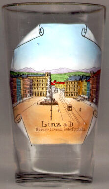
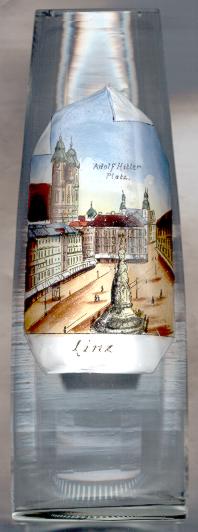
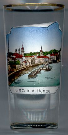
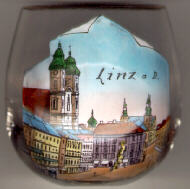
The Hauptplatz (Main Square) in the old town of Linz marks the location of the new settlement founded by the
Babenberg dukes in the 13th century. Like in so many towns of the Austrian Empire the square was called Kaiser-Franz-Josefsplatz
during the reign of Emperor Franz-Joseph I (ruled 1848–1916). During the Nazi era, the square was renamed
Adolf-Hitler-Platz (see glass no. 694, right). Today the square is simply called Hauptplatz (main square).
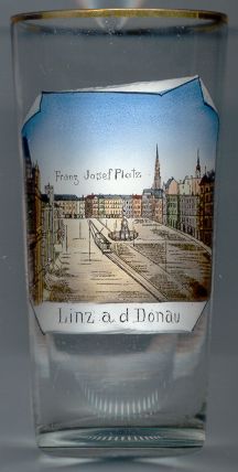
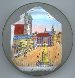
The Dreifaltigkeitssäule (Trinity column) in the center of the main square
was built in 1717–1723. The column is made of white marble and has a height of 20 m.
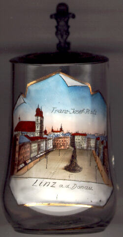
The Old Cathedral (Alter Dom) [background left]
was built in 1669–1678 as the Jesuit church of St Ignatius. The architect was Pietro Franceso Carlone,
a member of the famous family of architects. When Linz became the seat of a bishop in 1783/1785, the
church was elevated to the rank of a cathedral, which it retained until the completion of the new cathedral.
The choir stalls date from 1633 and originally were made for the monastery of Garsten.
The organ was created in 1789 by the famous organ builder Franz X. Chrisman for the monastery of Engelhartszell.
Anton Bruckner was organist of the church from 1855 until 1868.
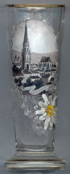
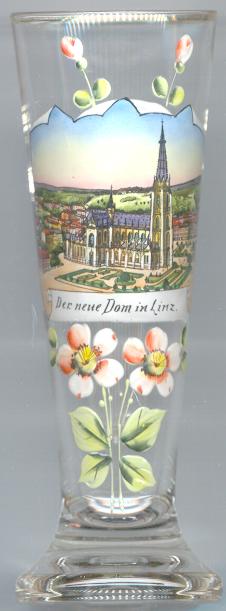
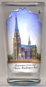
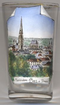
The New Cathedral (Neuer Dom, Maria-Empfängnis-Dom)
was begun in 1862. The construction of the huge cathedral in French neo-Gothic style took 62 years.
The church was designed for 20,000 people (at the time when the church was begun the whole town of Linz only had a population of 30,000!).
According to a popular, but unconfirmed legend the height of the mighty tower was limited to 134 m because the Imperial court did not allow a tower higher than that of
St. Stephen's Cathedral (137 m) in Vienna.
 Glasses no. 1300 [left] and no. 4555 [below left] show views of the cathedral just after the completion of
the votive chapel and presbytery (1862–1869) and the tower (1886–1901). Construction of the nave and transept started in 1902. The status of
cathedral church was transfered from the old cathedral in 1909. The other glasses [right, no. 2962, far right, no. 776, and below right,
no. 159] show the church after its completion in 1924.
Glasses no. 1300 [left] and no. 4555 [below left] show views of the cathedral just after the completion of
the votive chapel and presbytery (1862–1869) and the tower (1886–1901). Construction of the nave and transept started in 1902. The status of
cathedral church was transfered from the old cathedral in 1909. The other glasses [right, no. 2962, far right, no. 776, and below right,
no. 159] show the church after its completion in 1924.
Urfahr on the northern bank of the river consists of the 'statistical districts' Alt-Urfahr, Heilham,
Hartmayrsiedlung, Harbachsiedlung, Karlhofsiedlung and Auberg.
The oldest mention of its name is found in a document of 1290.
The name Urfahr is derived from the word 'überfahrt' ('crossing') which refered to the necessity of crossing the river when
coming from Linz.
In 1808 Urfahr obtained the status of a market town and in 1882 it was granted the status of a town.
In 1919 the municipality of Pöstlingberg was incorporated into Urfahr, and in the same year Urfahr itself became part of Linz.
Between 1945 and 1955 Urfahr was the seat of the Russian administration of the Soviet occupation zone in Austria. Because the
Danube at that time marked the demarcation line between the Soviet and American zones in Upper Austria (see map)
Urfahr also had an own municipal administration during that period.
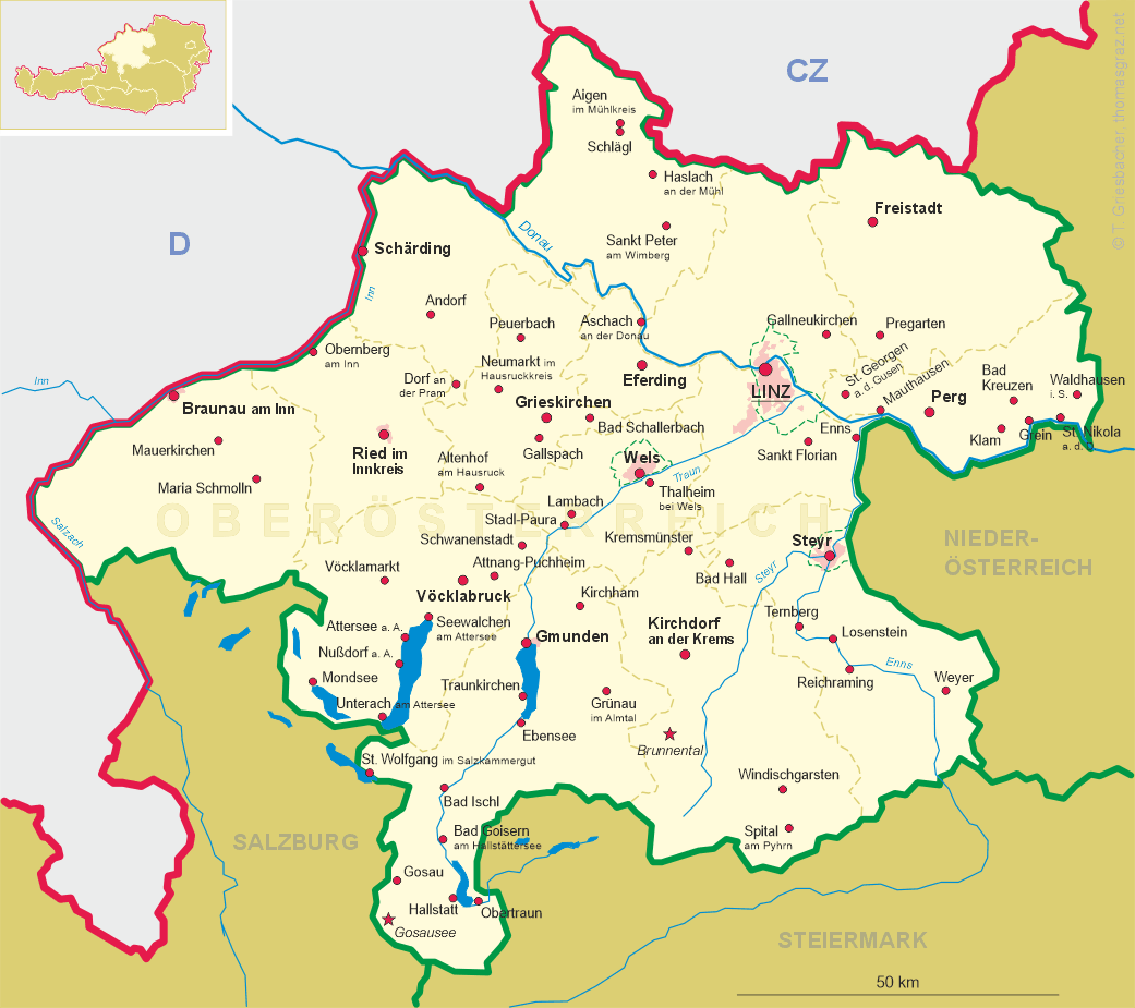
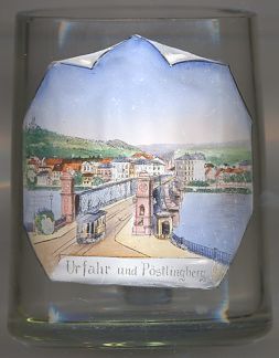
The first iron bridge across the Danube between Linz and Urfahr [left]
was built in 1870–1872 and replaced the older wooden bridge that had been damaged by a ship in 1868.
In 1938–1940 the old bridge was replaced by a modern construction ('Nibelungenbrücke'). The odlest bridge across the river
at this site had been built in 1497 and was the third bridge across the Danube in Austria (after Vienna
and Krems an der Donau).
(See also list of other basilicae minores depicted on glasses of this collection.)
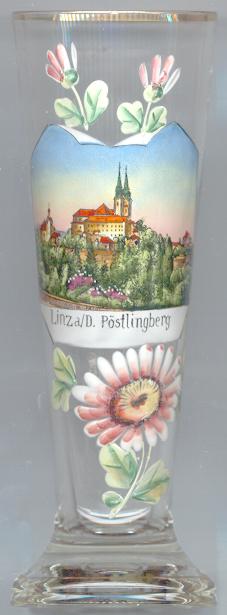
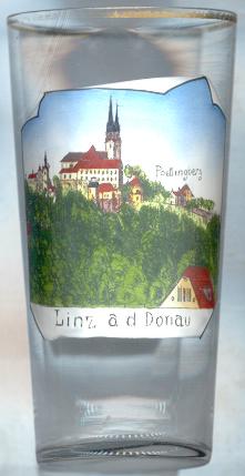
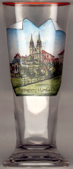
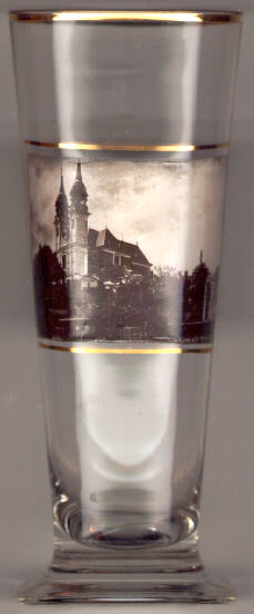
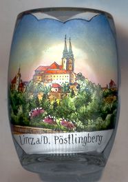
The pilgrimage church Sieben Schmerzen Mariä (Our Lady of the Seven Sorrows)
on the Pöstlingberg (539 m) was built in 1738–1774 in Baroque style. The place had become a pilgrimage site in 1720.
The roofs of the towers were modified in 1891/1892. Since 1960 the order of the
Oblates of St. Francis de Sales is in charge of the church.
In 1964 the church received the papal title of a Basilica minor.
![[scale]](lineal.jpg) contact: webmaster
contact: webmaster