
|
|
| ČESKÁ REPUBLIKA | CZECH REPUBLIC |
| Královéhradecký kraj | Hradec Králové region |
| Okres: Trutnov |
map →
Trutnov, the 'gateway to the Krkonoše' (Riesengebirge) mountains, is situated at an elevation of 418 m on the river Úpa (Aupa) in northern East Bohemia. A first slavic settlement seemed to have been formed during the 8th century. The present town was founded at the end of the 13th century by German settlers who called the place Trautenau (first mentioned in a document of 1301). Already in 1348/60, the settlement had obtained the formal status of a town.
 In 1866, one of the bloodiest battles of the Prussian-Austrian war took place on the hillls south of the town.
It was the only battle that had been won by the Austrian army during that war.
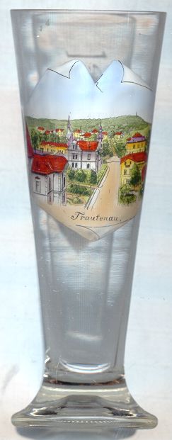
The picture on glass no. 1150 [left] shows the
In 1866, one of the bloodiest battles of the Prussian-Austrian war took place on the hillls south of the town.
It was the only battle that had been won by the Austrian army during that war.
The picture on glass no. 1150 [left] shows the  Šibenik
During the late 19th century, Trutnov became a centre of textile industry. Today it is one of the largest towns in eastern Bohemia.
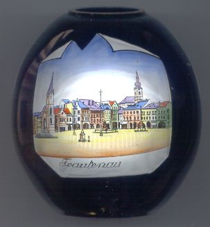
The picture on glass no. 1966 [right] shows
The Rübezahl fountain in the centre of the square [barely visible] was built in 1892.
The statue of Krakonoš (Rübezahl), the ruler of the mountains, on top of the fountain is 2 m high. Already in the 16th century a water supply,
consisting of 170 pinewood logs, led water to this place over a distance of 3 km. Until 1605 a woden fountain stood nearby. This was replaced in 1792 by a stone fountain
which was adorned by the sculpture of a dragon. When that fountain was replaced by the present one, the dragon sculpture was moved to the municipal park.
The Baroque Trinity column [also barely visible on the right]
was erected in 1704. The 11 m high column is headed by a statue of the Holy Trinity. Eight sculptures of saints, placed in two hierarchical circles are
placed around the column. In the 16th century this spot used to be the place of the whipping post.
The church of the Virgin Mary's Birth [right, background]
dates from 1782. It was built in late Baroque style with Rococo and Classicist details.
The church tower has a height of 64 meters.
The earliest mention of a church in this place already dates from 1283.
The town hall [right, no. 1966: left]
was built in neo-Gothic style after the catastrophic fire of 1861 had destroyed the Renaissance town hall of the 16th century. Before that time
the location of the town hall had been in the middle of the square, but after a large fire in 1583 it was moved to its present location.
The Renaissance sgraffito decorations were recreated in the 1980's. Since 1987 it is used again as the official town hall of Trutnov.
Trutnov is the birth-place of the Austrian aeronautic pioneer, Igo (Ignaz) Ettrich (1879–1967). The first flight of his aeroplane (still without
engine and steering) took place in Trutnov in 1907. Ettrich's glider reached a distance of 225 m and a maximum flying height of 17 m.
The first engine-powered long-distance flight (from Wiener Neustadt to Vienna and back) took place in 1910.
The aeroplane ('Ettrich-Taube', 'Ettrich's dove') today is exhibited at the Technical Museum in Vienna.
![[scale]](lineal.jpg)