
|
|
| DEUTSCHLAND | GERMANY |
| Bundesland: Sachsen-Anhalt | Saxony-Anhalt |
| Landkreis: Harz |
map →
The district town Wernigerode is situated at an altitode of 282 m at the northern slopes of the Harz mountain region of western Thuringia.
The earliest mention of Wernigerothe in a document dates from 1121, but according to a document of 1566 it should have existed already in 938 AD. In 1229 it had obtained the status of a town. When the counts of Wernigerode became extinct in 1429, Wernigerode came into possession of the counts of Stolberg. From 1714 on, Wernigerode was part of Brandenburg-Prussia. In 1807 it became part of the Napoleonic Kingdom of Westfalia, but returned to Prussia in 1815. On the 1st of July 2007 the districts Halberstadt, Quedlinburg and Wernigerode, and the city of Falkenstein/Harz (former district Aschersleben-Staßfurt) were merged; the seat of the new district Harz is in Halberstadt.
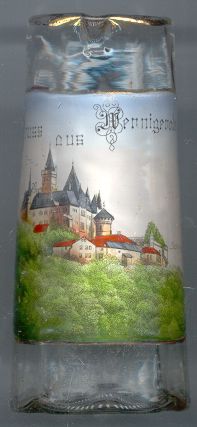
 Wernigerode castle [left, no. 1327, and right, no. 3134: top picture]
dates back to the beginning of the 12th century.
The counts of Stolberg enlarged the castle and transformed it to a mighty fortress. When the technical advancement of heavy weapons
reduced the usfulness of the fortress, it was transformed into a Baroque castle between 1674 and 1676. From 1710 on, the castle was the
residence of the Counts of Stolberg-Wernigerode. The counts (princes from 1890 on) further enlarged the residence between 1862 and 1885.
Until 1929 the castle remained the residence of the family. After that, parts of the castle were opened to the public.
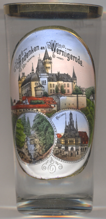
Wernigerode castle [left, no. 1327, and right, no. 3134: top picture]
dates back to the beginning of the 12th century.
The counts of Stolberg enlarged the castle and transformed it to a mighty fortress. When the technical advancement of heavy weapons
reduced the usfulness of the fortress, it was transformed into a Baroque castle between 1674 and 1676. From 1710 on, the castle was the
residence of the Counts of Stolberg-Wernigerode. The counts (princes from 1890 on) further enlarged the residence between 1862 and 1885.
Until 1929 the castle remained the residence of the family. After that, parts of the castle were opened to the public.
The Steinerne Renne [right, no. 3134: bottom left picture]
is a waterfall and natural monument near Wernigerode. In the gorge, numerous small waterfalls and rapids alternate with
quieter stretches of water in the Holtemme's rock and boulder-strewn riverbed. The entrance to the gorge below the
Hannekenbruch lies at a height of about 550 m above sea level and the exit is below Steinerne Renne railway station
at around 300 m, a height difference of about 250 metres. At 395 m the Kleine Renne empties into the
Steinerne Renne from the left. This natural feature was already described as the Steinrenne or steinerne Rinne
by the Early Modern Period. With the rise of tourism in the middle of the 19th century the Steinerne Renne became one of
the most popular beauty spots in the Harz. When the Harz and Brocken Railways were built a small station was even built
for the Steinerne Renne which still exists today. In 1869 a log cabin was built immediately next to the waterfall, the
predecessor of the present-day hotel.
[https://en.wikipedia.org/wiki/Steinerne_Renne]
The Town Hall was built in 1420 for count Heinrich of Wernigerode as a
'playhouse' above the wine cellar. In 1427 it was donated to the town and it remained in use for carnival games
but also as a commerce and court place. The two characteristic narrow oriels with the tall pitched roofs were added
to the half-timbered house in 1494–1498. When the nearby original town hall burnt down in 1528, the town
purchased the house next to the playhouse and from 1539 to 1544 remodeled both to become the new town hall.
The ridge turret on the roof was added in 1699.
[https://de.wikipedia.org/wiki/Rathaus_Wernigerode]
![[scale]](lineal.jpg)