
|
|
| DEUTSCHLAND | GERMANY |
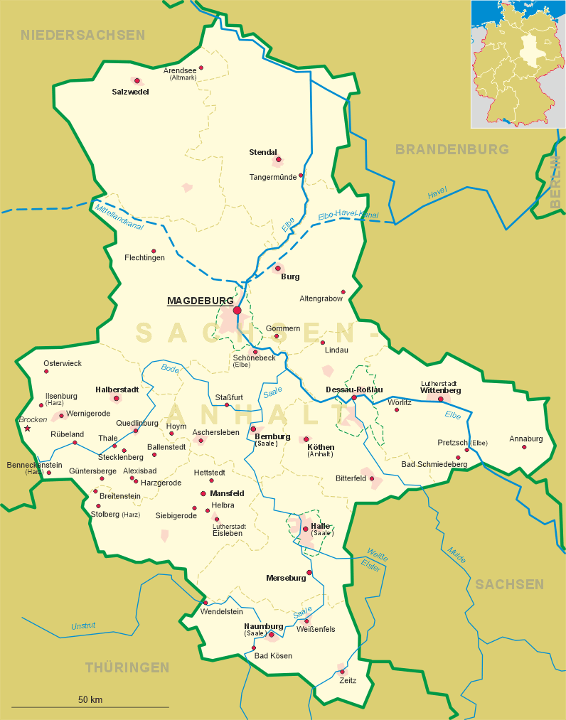
| Bundesland: Sachsen-Anhalt | Saxony-Anhalt |
| Landkreis: Mansfeld-Südharz |
map →
Stolberg (Harz) is situated at an elevation of 340 m in the Unterharz (Lower Harz) region in the nature reserve Harz / Sachsen-Anhalt. Stolberg has a population of about 1,300 (2009) and since 2010 is part of the municipality Südharz.
 Stolberg was established as a settlement for miners in around AD 1000, although there is evidence of mining in the area
as far back as 794. The name of the name is derived from the German words Stollen ('[mining] gallery') and
Berg ('hill'). Iron, copper, silver, tin and gold were extracted there. Town status was awarded to Stolberg
before 1300. During the German Peasants' War, Stolberg was the site of several battles, the peasants being led by
Thomas Müntzer who was born in the town. Coins were minted in Stolberg as early as the High Middle Ages, the industry
reaching its heyday during the 16th century. By contrast, mining ceased in the 17th century. From its earliest days,
Stolberg had been the residence and family seat of the counts of Stolberg. In 1548 it became the seat of Stolberg-Stolberg.
In 1645 the County of Stolberg split into two new counties, Stolberg-Stolberg and Stolberg-Wernigerode.
In 1738 the counts of Stolberg were forced to recognize the suzerainty of the Electorate of Saxony. The town was awarded
to the Kingdom of Prussia in the 1815 Congress of Vienna and Stolberg was subsequently administered
by the Prussian Province of Saxony. At the beginning of the 20th century, Stolberg became a tourist town. In 1923, a railway
to Berga-Kelbra was opened. The town has been a health resort since 1946. On 1 September 2010, Stolberg and Wickerode
were incorporated into the municipality of Südharz ("South Harz"), which had been formed on 1 January of that year
by a merger of the former municipalities of Bennungen, Breitenstein, Breitungen, Dietersdorf,
Drebsdorf, Hainrode, Hayn, Kleinleinungen, Questenberg, Roßla, Rottleberode, Schwenda and Uftrungen.
Stolberg was established as a settlement for miners in around AD 1000, although there is evidence of mining in the area
as far back as 794. The name of the name is derived from the German words Stollen ('[mining] gallery') and
Berg ('hill'). Iron, copper, silver, tin and gold were extracted there. Town status was awarded to Stolberg
before 1300. During the German Peasants' War, Stolberg was the site of several battles, the peasants being led by
Thomas Müntzer who was born in the town. Coins were minted in Stolberg as early as the High Middle Ages, the industry
reaching its heyday during the 16th century. By contrast, mining ceased in the 17th century. From its earliest days,
Stolberg had been the residence and family seat of the counts of Stolberg. In 1548 it became the seat of Stolberg-Stolberg.
In 1645 the County of Stolberg split into two new counties, Stolberg-Stolberg and Stolberg-Wernigerode.
In 1738 the counts of Stolberg were forced to recognize the suzerainty of the Electorate of Saxony. The town was awarded
to the Kingdom of Prussia in the 1815 Congress of Vienna and Stolberg was subsequently administered
by the Prussian Province of Saxony. At the beginning of the 20th century, Stolberg became a tourist town. In 1923, a railway
to Berga-Kelbra was opened. The town has been a health resort since 1946. On 1 September 2010, Stolberg and Wickerode
were incorporated into the municipality of Südharz ("South Harz"), which had been formed on 1 January of that year
by a merger of the former municipalities of Bennungen, Breitenstein, Breitungen, Dietersdorf,
Drebsdorf, Hainrode, Hayn, Kleinleinungen, Questenberg, Roßla, Rottleberode, Schwenda and Uftrungen.
 Stolberg castle [top] dates to the 13th century and stands above the town
on a hill with steep drops on three sides. Its oldest element, the round tower, dates to the time around 1200, the more
recent elements were built in the Renaissance style between 1539 and 1547. In the southeast wing is the Classicist
Great Reception Room (Großes Empfangszimmer) and the Red Room (Roter Saal) designed by Karl Friedrich Schinkel. The castle
was given its present appearance thanks to rebuilding between 1690 and 1700. Until they were dispossessed in 1945, the
castle was owned by the family of the Prince of Stolberg-Stolberg. Since 2003 it has been completely restored and renovated
by the German Foundation for Monument Conservation. Since March 2008 parts of the castle have been open to the public again
and used as a tourist centre and reception venue (Haus des Gastes).
Stolberg castle [top] dates to the 13th century and stands above the town
on a hill with steep drops on three sides. Its oldest element, the round tower, dates to the time around 1200, the more
recent elements were built in the Renaissance style between 1539 and 1547. In the southeast wing is the Classicist
Great Reception Room (Großes Empfangszimmer) and the Red Room (Roter Saal) designed by Karl Friedrich Schinkel. The castle
was given its present appearance thanks to rebuilding between 1690 and 1700. Until they were dispossessed in 1945, the
castle was owned by the family of the Prince of Stolberg-Stolberg. Since 2003 it has been completely restored and renovated
by the German Foundation for Monument Conservation. Since March 2008 parts of the castle have been open to the public again
and used as a tourist centre and reception venue (Haus des Gastes).
The church of St. Martin [bottom right] goes back to a prewvious,
late Romanesque church of the early 13th century, of which the lower parts of the church tower remain. The present,
early Gothic church was built from around 1300. In the 15th ccentury, beginning in 1484, the church was considerably
enlarged: the crypt, south transcept and sycristy were completed in 1487, the chancel was finished in 1490, the roof
and outer walls followed in the subsequent years. However, due to lack of money the later parts were carried in more
and more simple designs and the old church tower was not rebuilt at all (and therefore seems disproportionately small).
Further changes to the structure followed in the 18th century. A thorough renovation and remodeling of the interior
was begun in 1883.
[https://de.wikipedia.org/wiki/Stolberg_(Harz), https://en.wikipedia.org/wiki/Stolberg_(Harz);
https://en.wikipedia.org/wiki/Südharz; https://en.wikipedia.org/wiki/Stolberg_Castle;
http://www.stadt-stolberg.de/Die_Martinikirche]
![[scale]](lineal.jpg)