
|
|
| ÖSTERREICH | AUSTRIA |
| Bundesland: Steiermark | Styria |
| Bezirk: Graz-Umgebung |
map →

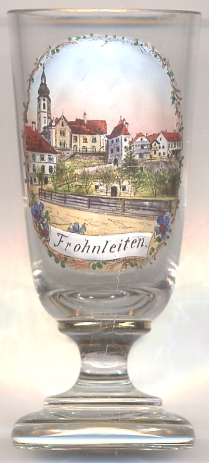
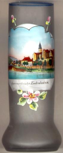 Frohnleiten is situated at an elevation of 438 m in the Mur valley about 25 km north of Graz.
The municipity has a population of about 6,000 (2012).
Frohnleiten is situated at an elevation of 438 m in the Mur valley about 25 km north of Graz.
The municipity has a population of about 6,000 (2012).
Frohnleiten was founded around 1280 by the counts of Pfannberg in order to protect a bridge across
the river Mur. The earliest written document that mentions Vreyliten dates from 1306.
When the last count of Pfannberg died in 1362 without male heir, it came in possession of the Habsburg dukes of Styria who
granted the market town important privileges.
The opening in 1844 of the railroad from Mürzzuschlag to Graz (later part of the Southern Railroad
from Vienna to Trieste) did not bring advantages for the community because most of the
traffic simply passed by. However, this changed in 1867 when a cold-water cure establishment was founded and Frohnleiten
thus became a spa place. In 1887 a paper factory was founded which until today is an important economical factor for Frohnleiten.
The municipalities of Frohnleiten and Mauritzen were merged in 1952 and at the same time the new municipality obtained the official status of a market town.
Rothleiten was incorporated into Frohnleiten in 1992. In 2002, Frohnleiten was granted the official status of a town.
[https://de.wikipedia.org/wiki/Frohnleiten, http://www.frohnleiten.org]
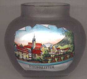 The silhouette of the old town is dominated by the tower of the
 former Katharinenkirche (St. Catherine's).
The church developed out of an earlier chapel of around 1300. The chancel dates from
about 1400. The upper parts of the tower were renewed in 1763 following a destruction by fire.
In 1788, the church was exsecrated and transformed into residential premises.
former Katharinenkirche (St. Catherine's).
The church developed out of an earlier chapel of around 1300. The chancel dates from
about 1400. The upper parts of the tower were renewed in 1763 following a destruction by fire.
In 1788, the church was exsecrated and transformed into residential premises.
![[scale]](lineal.jpg)