
|
|
| DEUTSCHLAND | GERMANY |
| Bundesland: Baden-Württemberg | |
| Regierungsbezirk: Tübingen | |
| Landkreis: Biberach |
map →

 Riedlingen is situated at an elevation of 533 m between the foothills of the Schwäbische Alb mountains, the
Danube valley and the Bussen, the landmark mountain of Upper Swabia.
Riedlingen is situated at an elevation of 533 m between the foothills of the Schwäbische Alb mountains, the
Danube valley and the Bussen, the landmark mountain of Upper Swabia.
In all likelyhood Riedlingen was founded by the Alemanni. The earliest written mention is found in a document dated to 835 AD. It was probably around 1250 that the counts of Veringen granted Riedlingen the privileges of a town; the earliest document mentioning this fact dates from 1255. Around 1300 the town came in possession of the Habsburgs who soon after that impawned it to Sewers (Truchsessen) of Waldburg. It took until 1680 that Riedlingen returned to Austria. Until the Peace of Pressburg (Bratislava) of 1805 Riedlingen was part of Anterior Austria (see map). In 1806 it became part of the Kingdom of Württemberg and became the seat of a regional district administration (Oberamt). In 1938 the administrative districts Riedlingen and Saalgau were amalgamated into the new district Saalgau. Since 1973 Riedlingen is part of the district Biberach.
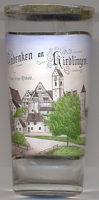
The Catholic  parish church Sankt Georg [background] is the landmark of the town.
The church was built betwenn the 13th and 15th centuries. The characteristic tower overlooking the old town has a height of
43 m. If you look closely, you can make out the dial of the church clock as it was located on the tower around 1900.
During a restoration in 1989 the clock was moved a little more upward to restore it to its original position from the Gothic
period.
parish church Sankt Georg [background] is the landmark of the town.
The church was built betwenn the 13th and 15th centuries. The characteristic tower overlooking the old town has a height of
43 m. If you look closely, you can make out the dial of the church clock as it was located on the tower around 1900.
During a restoration in 1989 the clock was moved a little more upward to restore it to its original position from the Gothic
period.
The slim, cylindrical Zellemees tower [background right]
in the southeastern corner of the former town wall dates from the 13th/14th century and originally served as peel and as jail.
![[scale]](lineal.jpg)