
|
|
| DEUTSCHLAND | GERMANY |
| Bundesland: Rheinland-Pfalz | Rhineland-Palatinate |
| Landkreis: Kaiserslautern |
map →
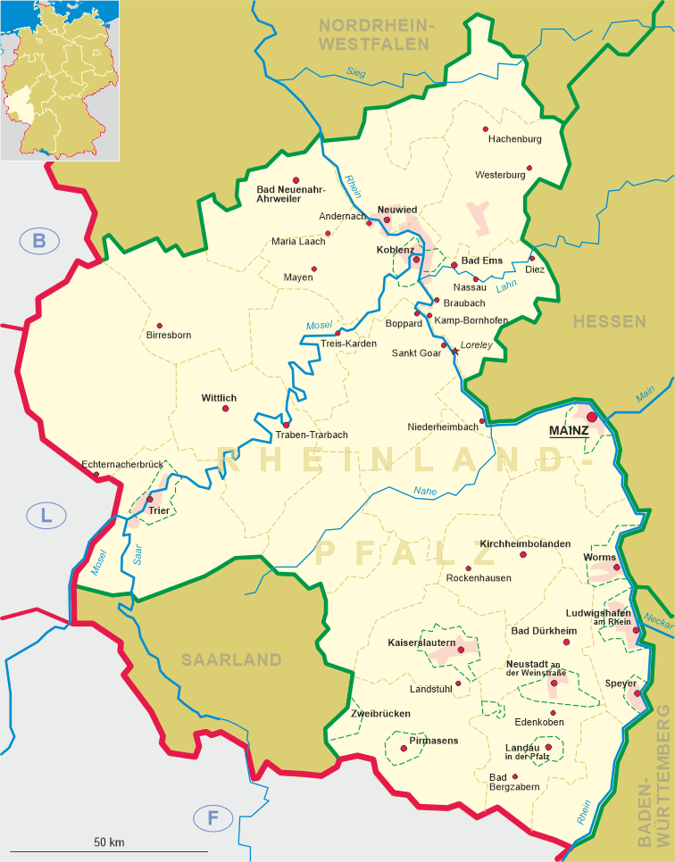
Landstuhl is situated at an elevation of 238 m at the northwestern edge of the Pfälzerwald low mountain region. Landstuhl has a population of about 9,200 (2004) and is also the seat of the administration of the collective municipality ('Verbandsgemeinde') Landstuhl, which consists of the municipalities Bann, Hauptstuhl, Kindsbach, Landstuhl, Mittelbrunn and Oberarnbach.
 The oldest traces of human settlements are tombs of the La Tène period (c. 5th to 1st century BC).
A wellspring sanctuary from the Celtic period was unearthed in the area between Landstuhl and nearby Kindsbach.
A Roman settlement existed between the 1st and 4th century AD.
The oldest traces of human settlements are tombs of the La Tène period (c. 5th to 1st century BC).
A wellspring sanctuary from the Celtic period was unearthed in the area between Landstuhl and nearby Kindsbach.
A Roman settlement existed between the 1st and 4th century AD.
In the mid-12th century Landstuhl became the centre of a feudal domain, which in the 15th century came in possession of the Sickingen family. The best-known member of this family was certainly Franz von Sickingen, a leader of the revolting Rhenish and Swabian knights in the early Reformation period. In 1522 the council of regency placed him under the ban, to which he replied, in the spring of 1523, by plundering Kaiserslautern. The archbishop of Trier, the landgrave of Hesse and the count palatine of the Rhine decided to move against him, and having obtained help from the Swabian League, marched on Landstuhl. Sickingen refused to negotiate, and during the siege was seriously wounded. This attack was one of the first occasions on which artillery was used, and breaches were soon made in an otherwise impregnable fortress. On 6 May 1523 Sickingen was forced to capitulate, and on the following day he died. Sickingen's castle Nanstein was destroyed by the French in 1689. The Landstuhl domains became part of Bavaria in 1815. Since 1946, Landstuhl is part of Germany's state of Rheinland-Pfalz.
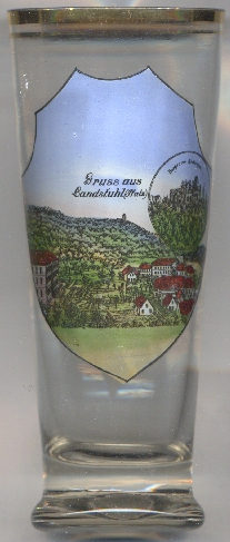
 Nanstein castle [left, no. 4309: right inset], on the picture on the glass labeled as
Burgruine Sickingen, was built around 1152. The medieval spur castle, situated above a 15 m high sandstone ledge, was originally part of
the Hohenstaufen defenses guarding the imperial lands in the south-western Palatinate. Imperial Knight and Protestant reformer Franz von Sickingen
modernised the castle in the 16th century and turned it into a citadel that was supposed to withstand the artillery of the age. In 1523 (during
the so-called "Knights' Revolt"), the castle was besieged by the archbishop of Trier, the Elector Palatine, and the Landgrave of Hesse. Sickingen fell
mortally wounded during the siege. Sickingen's sons received the partially destroyed castle back in 1542 (as a feudal tenure), and immediately rebuilt
it in a Renaissance style. In 1668, it was again captured by the Elector Palatine who had it partially destroyed. French troops destroyed other parts
in 1689. In the following centuries several repairs were made, but it remains a castle ruin.
Nanstein castle [left, no. 4309: right inset], on the picture on the glass labeled as
Burgruine Sickingen, was built around 1152. The medieval spur castle, situated above a 15 m high sandstone ledge, was originally part of
the Hohenstaufen defenses guarding the imperial lands in the south-western Palatinate. Imperial Knight and Protestant reformer Franz von Sickingen
modernised the castle in the 16th century and turned it into a citadel that was supposed to withstand the artillery of the age. In 1523 (during
the so-called "Knights' Revolt"), the castle was besieged by the archbishop of Trier, the Elector Palatine, and the Landgrave of Hesse. Sickingen fell
mortally wounded during the siege. Sickingen's sons received the partially destroyed castle back in 1542 (as a feudal tenure), and immediately rebuilt
it in a Renaissance style. In 1668, it was again captured by the Elector Palatine who had it partially destroyed. French troops destroyed other parts
in 1689. In the following centuries several repairs were made, but it remains a castle ruin.
The picture on glass no. 2261 [right] shows a view of the
Stadtpark three
Landstuhl is the site of the United States' largest military hospital outside the U.S.A.
[https://de.wikipedia.org/wiki/Landstuhl;
https://en.wikipedia.org/wiki/Nanstein_Castle]
![[scale]](lineal.jpg)