
|
|
| DEUTSCHLAND | GERMANY |
| Bundesland: Baden-Württemberg | |
| Regierungsbezirk: Stuttgart | |
| Stadt: Pforzheim |
map →

Pforzheim is situated at an elevation of 263 m at the confluence of the rivers Enz, Nagold and Würm in the northwest of Germany's state of Baden-Württemberg. Pforzheim is administered as a distict in its own right but at the same time also is the administrative seat of the Enz district. Pforzheim has a population of about 118,800 (2007) and is Baden-Württemberg's eighth-largest city.
Around AD 90, the Romans established a settlement at this place which they called Portus. It was located on a road that connected the military camp Argentorate (today Strasbourg in France) and the military camp at Cannstadt (today a suburb of Stuttgart. The Roman settlement was destroyed in the 3rd century when the Franks and Alemanni overran the Upper Germanic Limes. The earliest written mention of Phorzheim dates from 1064. The 'old town' of Pforzheim obtained the status of a market town prior to 1080. At that time it belonged to the estates of the monastery of Hirsau. The 'new town' was founded after 1150 to the west of the old town. By 1200 the new town had obtained the privileges of a town. This new town was chosen in 1220 by the margraves of Baden as their residence.
 On of the great German humanists, Johannes Reuchlin, was born in Pforzheim in 1455. Later, the Latin School of Pforzheim developed into one of the
most prominent schools in southwestern Germany. Among its pupils were Reuchlin himself, his nephew Philipp Melanchthon and Simon Grynaeus.
In 1463 Margrave Karl I of Baden was forced to transfer the town as a fiefdom to the Elector Palatine after losing the Battle of Seckenheim.
He then began to build a new palace in modern Baden-Baden. Between 1535, when the margraviate was partitioned, and 1565
Pforzheim again became the residence of one line of the Margraves of Baden. In the latter year, the residence was moved to Durlach (today part of
Karlsruhe. In 1556 the Lutheran Faith was introduced in the margraviate of Baden-Durlach. Althogh the residence
was moved finally to Durlach in 1565, Pforzheim still remained one of the important administrative centres of the margraviate.
During the Thirty Years' War (1618–1648), the old town was burnt by Bavarian troops, and although it was rebuilt, without fortifications,
after the war it later disappeared from all records and only the new town survived. During the Nine Years' War (1688–1697, War of the
Palatiian Succession) Pforzheim was occupied by French troops in 1688. When the troops left in the following year, apparently because an
Imperial army was approaching, they set Pforzheim on fire and thus large parts of the town were destroyed.
On of the great German humanists, Johannes Reuchlin, was born in Pforzheim in 1455. Later, the Latin School of Pforzheim developed into one of the
most prominent schools in southwestern Germany. Among its pupils were Reuchlin himself, his nephew Philipp Melanchthon and Simon Grynaeus.
In 1463 Margrave Karl I of Baden was forced to transfer the town as a fiefdom to the Elector Palatine after losing the Battle of Seckenheim.
He then began to build a new palace in modern Baden-Baden. Between 1535, when the margraviate was partitioned, and 1565
Pforzheim again became the residence of one line of the Margraves of Baden. In the latter year, the residence was moved to Durlach (today part of
Karlsruhe. In 1556 the Lutheran Faith was introduced in the margraviate of Baden-Durlach. Althogh the residence
was moved finally to Durlach in 1565, Pforzheim still remained one of the important administrative centres of the margraviate.
During the Thirty Years' War (1618–1648), the old town was burnt by Bavarian troops, and although it was rebuilt, without fortifications,
after the war it later disappeared from all records and only the new town survived. During the Nine Years' War (1688–1697, War of the
Palatiian Succession) Pforzheim was occupied by French troops in 1688. When the troops left in the following year, apparently because an
Imperial army was approaching, they set Pforzheim on fire and thus large parts of the town were destroyed.
In 1767 a watch and jewellery factory was established. The jewellery industry became one of the most important economic factors of the town. Watchmaking was given up later and only was started again in 1900. As Pforzheim was not a battle field in World War I it survived the war without damage. However, on 23 February 1945, Pforzheim was bombed in one of the most devastating area bombardments of World War II. About one quarter of the town's population, over 17,000 people, were killed in the air raid, and about 83% of the town's buildings were destroyed. After the war Pforzheim was gradually rebuilt, giving Pforzheim a quite modern look.
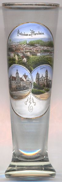
The  Old Town Hall [left, no. 2458: bottom left picture]
was built in 1910/1911 in place of the first town hall of 1471 which itself had been used before as a merchants' hall.
The building was largely destroyed by a bomb raid on 23rd of February 1945. Next to it, the new town hall, a modern concrete building,
was built in 1969–1973. The remains of the old town hall had been rebuilt provisorily, and in 2001 the complex was completely
reshaped by contemporary additions but retaining and repairing the remains of the old sandstone façade and the inner courtyard.
Old Town Hall [left, no. 2458: bottom left picture]
was built in 1910/1911 in place of the first town hall of 1471 which itself had been used before as a merchants' hall.
The building was largely destroyed by a bomb raid on 23rd of February 1945. Next to it, the new town hall, a modern concrete building,
was built in 1969–1973. The remains of the old town hall had been rebuilt provisorily, and in 2001 the complex was completely
reshaped by contemporary additions but retaining and repairing the remains of the old sandstone façade and the inner courtyard.
The Saalbau [left, no. 2458: bottom right picture]
was built in 1898–1899 and was designed by the architect Alfons Kern. The theatre was used for theatrical performances and large concerts and events.
During World War I the building was temporarily used as an army hospital. Between the world wars it was also used frequently for
political events. On 23rd of February 1945, the Saalbau was completely destroyed. In its place the "Reuchlinhaus" was built in 1958–1961
as Pforzheims municipal culture centre.
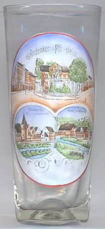
Sedanplatz (Sedan Square) [left, no. 2378: top picture] is located in the southwestern part of
Pforzheim's inner city and is delimited by Bleichstraße, Dillsteiner Straße and Weiherstraße.
The square was named for the Battle of Sedan which took place on 1st and 2nd September 1870 near Sedan in northeastern France during the French-German War.
On 2nd September, the Prussian army captured the French emperor Napoléon III together with some 100,000 French soldiers. Napoléon was
brought to Wilhelmshöhe Castle in Kassel where he was held until March 1871. The war ended with a complete
defeat of France. Napoléon III was exiled to Great Britain where he stayed until his death in 1873. The Prussian victory
in the Battle of Sedan was celebrated as a public holiday in Germany until 1918.
The Schelmenturm (Rogue's Tower) [left, no. 2378: bottom left picture] in the Untere Au (Lower Pasture)
stood on the bank of the river Enz at the northeastern corner of the fortification of the Auer Vorstadt (Au Suburb).
The tower was incorporated into an ensemble of half-timbered houses and was the last of 4 towers that in former centuries had guarded
this part of the town. It is most likely that it had been built in the 15th century. When the course of the river Enz was artificially
changed in 1907–1908 the Schelmenturm was pulled down. Originally it was planned to rebuild the tower later, and therefore all its
bricks were numbered and stored. However, during the bomb raids of 1945 they were lost.
The bottom right picture on glass no. 2378 shows a view of the
Würm
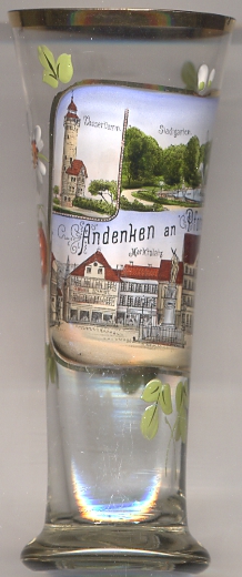
 The Wasserturm (water tower) [left, no. 2877: top left picture]
on the hill Rodrücken ws built in 1899–1900 by the architect Alfons Kern. The tower has a height of 45 and originally was topped by a
wooden lookout turret. This turret was damaged during a tornado in 1968 so severely that it had to be removed. At first, the tower was given a provisional
wooden roof; several years later, this provisiona construction was replaced by a new lookout turret, this time made of concrete and glass.
[http://wikimapia.org/4813522/de/Wasserturm-auf-dem-Rodrücken, http://www.pfenz.de/wiki/Wasserturm_auf_dem_Rodrücken]
The Wasserturm (water tower) [left, no. 2877: top left picture]
on the hill Rodrücken ws built in 1899–1900 by the architect Alfons Kern. The tower has a height of 45 and originally was topped by a
wooden lookout turret. This turret was damaged during a tornado in 1968 so severely that it had to be removed. At first, the tower was given a provisional
wooden roof; several years later, this provisiona construction was replaced by a new lookout turret, this time made of concrete and glass.
[http://wikimapia.org/4813522/de/Wasserturm-auf-dem-Rodrücken, http://www.pfenz.de/wiki/Wasserturm_auf_dem_Rodrücken]
The Stadtgarten (municipal park) [left, no. 2877: top right picture]
is located between the river Nagold and the Mühlkanal. The park was opened in 1885.
[http://enz.info/ausflugsziele/stadtgarten-pforzheim/.http://www.pforzheim.de/umwelt-natur/naherholung/naherholung-in-der-stadt.html]
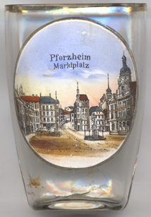
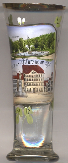
The Marktplatz (Market Square) [left, no. 2877: bottom picture; and right, no. 4105]
is located between Westliche and Östliche Karl-Friedrich-Straße. The square marked the city centre already in the 13th century.
In 1975 the square became part of the inner city pedestrian zone.
[http://www.pfenz.de/wiki/Marktplatz_(Pforzheim)]
The old Markgraf-Ernst-Brunnen [left, no. 2877: bottom picture: centre]
marked the centre of the town. In the 16th century it was topped by a Roland statue, signifying the city rights.
The fountain was named for Margrave Ernst I of Baden-Pforzheim (1482–1553, r.1533–1553).
In 1535 Ernst moved his residence from Sulzberg to Pforzheim, which at the time was the largest town in his territory. Pforzheim
remained the residence town until 1565 when Ernst's son Karl II moved the residence to Durlach (today part of Karlsruhe).
The foutain was removed, for unknown reasons, in 1950.
[http://www.hs-pforzheim.de/De-de/Hochschule/Presse_Oeffentlichkeitsarbeit/Pressearbeit/Pressemitteilungen/Seiten/MarktbrunnenWirtschaftsingenieure.aspx,
https://de.wikipedia.org/wiki/Ernst_(Baden-Durlach)]
![[scale]](lineal.jpg)