
|
|
| DEUTSCHLAND | GERMANY |
| Bundesland: Nordrhein-Westfalen | North Rhine-Westphalia |
| Regierungsbezirk: Düsseldorf | |
| Kreis: Wesel |
map →
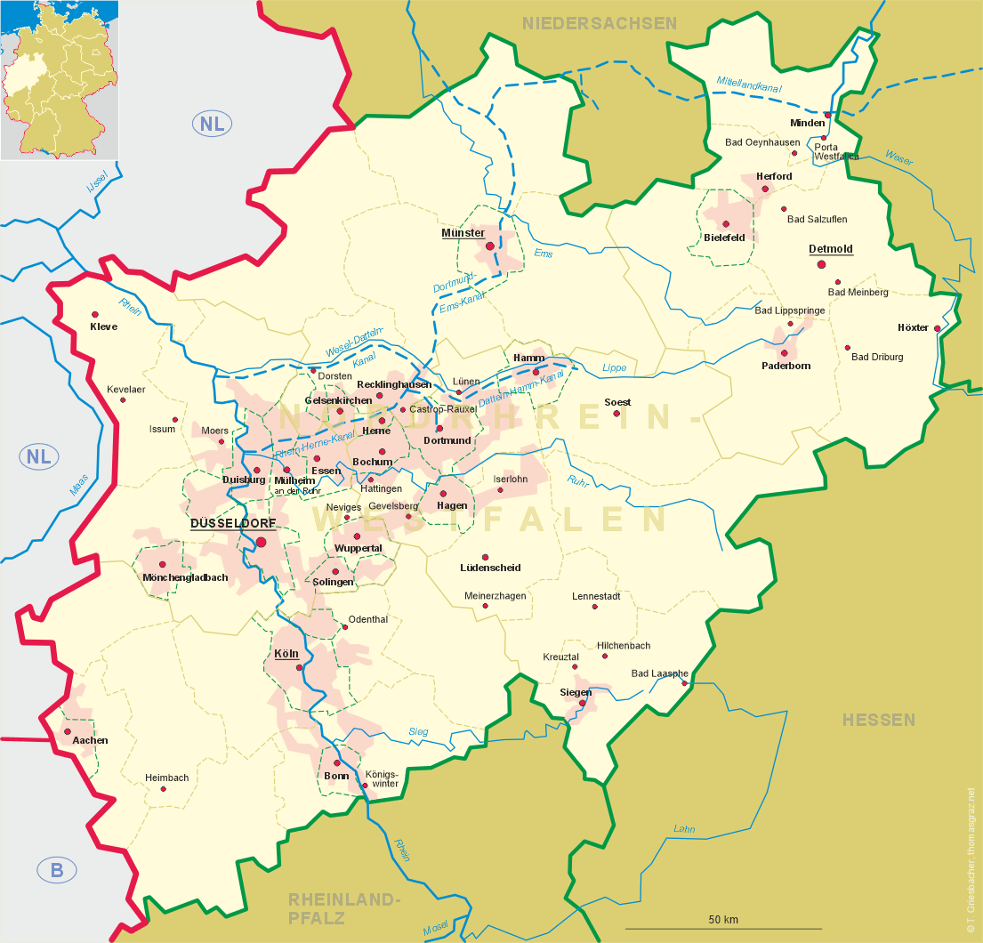
 Moers is situated at an elevation of 30 m in the Lower Rhine region of Germany's state of Nordrhein-Westfalen.
The municipality has a population of about 107,200 (2006).
Moers is situated at an elevation of 30 m in the Lower Rhine region of Germany's state of Nordrhein-Westfalen.
The municipality has a population of about 107,200 (2006).
Archaeological finds show that the earliest races of human settlements in the area date from about 2500 BC. The Roman military settlement Asciburgium was founded in 12/11 BC. In 69 BC the settlement was destroyed during the Batavian rebellion. It was rebuilt after that but was finally abandoned around AD 85. The earliest written mention of Murse is found in a register of the monastery of Werden, dating from the 9th century. The name is probably derived from the fact that at that time the area contained many moors or swamps (in modern German: Moor). The oldest parts of Moers castle date from around 1200. Betwenn about 1270 and 1280 the river Rhine changed its course so that the settlement no longer was located in the immediate vicinity of the river but was located about 7 km west of it. In 1300, Moers was chartered as a town by a privilege issued by the German King Albrecht I, Duke of Austrian and Styria. In 1493 the county of Moers waws inherited by the counts of Wied-Runkel; in 1519 it passed to the counts of Neuenahr. In 1560 the Protestant faith was introduced by the counts. When the counts supported Gebhard I Truchsess of Waldburg, the former archbishop of Cologne who had converted to Protestantism, Moers became involved in the so-called Truchsessian War (1583–1588) between Gebhard on one side and Bavarian and Spanish troops, who had been called to help by the Cologne cathedral chapter, on the other side. The war ended with a vitory of the catholic side. In 1594 the last coutness of Moers bequeathed the town to her relative, Moritz of Nassau, prince of Orange, who besieged the city and conquered it in 1597. In 1702 Moers was inherited by Prussia and received the formal status of a principality in 1706. As such, the city obtained the status of immediacy to the empire. However, Moers was captured for Prussia in 1712 by Prince Leopold I of Anhalt-Dessau ('the Old Dessauer'). In 1794 Moers was captured by French troops and in 1798 was incorporated into the département de la Roer (capital Aix-la-Chapelle, i.e. Aachen). After the Congress of Vienna (1815) the Lower Rhine region was returned to Prussia. In 1816, Moers became part of the Prussian province Jülich-Kleve-Berg, which later became the Prussian Rhine province. After World War I Moers remained occupied by Belgian troops until 1926. At the end of World War II, Moers was occupied by American troops. Beginning in 1965, the historical old town centre was gradually restored.
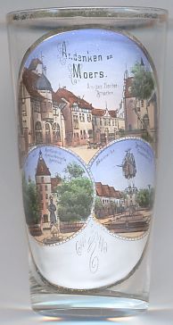
The top picture on glass no. 2386 shows a view of the town quarter at the Neutorbrücke (New Gate Bridge).
The bottom left picture shows a view of  Moers castle. The castle is a popular landmark of the city.
The oldest parts of the castle were built around 1200. During the 13th century the castle was enlarged and received a brick wall fortification,
one of the oldest extant examples of its kind in North Rhine-Westfalia. Later extensions of the castle date from the 15th, 16th and 19th centuries.
In 1905 the castle was purchased by the city of Moers and became the home of the museum of local history.
Moers castle. The castle is a popular landmark of the city.
The oldest parts of the castle were built around 1200. During the 13th century the castle was enlarged and received a brick wall fortification,
one of the oldest extant examples of its kind in North Rhine-Westfalia. Later extensions of the castle date from the 15th, 16th and 19th centuries.
In 1905 the castle was purchased by the city of Moers and became the home of the museum of local history.
The monument depicted in front of the castle is the monument
The bottom right picture shows a view of Neumarkt (New Market) with the
monument
![[scale]](lineal.jpg)