
|
|
| DEUTSCHLAND | GERMANY |
| Bundesland: Freistaat Sachsen | Saxony |
| Landkreis: Erzgebirgskreis |
map →

 Thalheim is situated at an elevation of 450 m in the Zwönitz valley, about 5 km east of
Stolberg and 15 km suth of Chemnitz in the lower parts of the Erzgebirge (Ore Mountains)
region. The municipality has a population of about 6,300 (2016).
Thalheim is situated at an elevation of 450 m in the Zwönitz valley, about 5 km east of
Stolberg and 15 km suth of Chemnitz in the lower parts of the Erzgebirge (Ore Mountains)
region. The municipality has a population of about 6,300 (2016).
Thalheim was founded presumably in the 12th century (usually assumed as 1184). The writteen mentioning is found in a document of 1447. Thalheim obtained the status of a town in 1925.
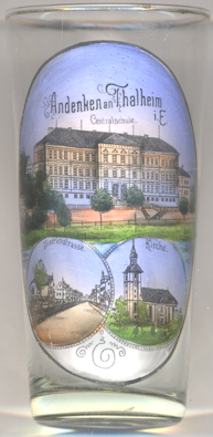
The  Centralschule ('central school') [left, no. 3437: top picture]
was built in 1888/1889.
Centralschule ('central school') [left, no. 3437: top picture]
was built in 1888/1889.
The bottom left picture shows a view of
The
Other glasses in this collection show views from Thalheim bei Wels, Austria.
[https://de.wikipedia.org/wiki/Thalheim/Erzgeb., https://www.thalheim-erzgeb.de/leben/geschichte/]
Friedrichstraße.
Lutheran church [left, no. 3437: bottom right picture]
was built in 1849/1850 in place of an older structure. The earliest mention of a church in Thalheim dates from 1346.
![[scale]](lineal.jpg) contact: webmaster
contact: webmaster