
|
|
| SCHWEIZ / SUISSE / SVIZZERA / SVIZRA | SWITZERLAND |
| Neuenburg / Neuchâtel / Neuchâtel / Neuchâtel |
map →
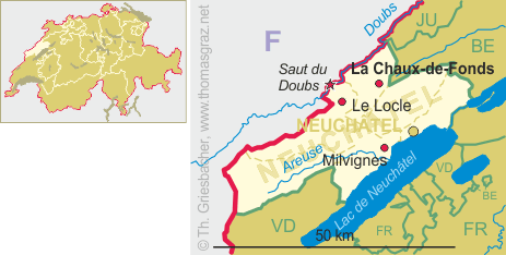
Milvignes is situated at an elevation of 456 m on the northwestern shore of Lake Neuchâtel. The municipality was created on 1 January 2013 by merging the formerly independent municpalities of Auvernier, Bôle and Colombier. The population is about 9,000 (2017). The name of the new municipality was taken from the now largest vineyard of the Canton Neuchâtel.
Auvernier forms the eastern part of the municipality of Milvignes. Its population is about 1,600 (2012).
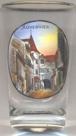
Settlement has flourished since the Bronze Age in the vicinity of Auvernier, as evidenced by the large amount of material excavated by archaeologists, some of which is now in the British Museum in London, including a hoard of penannular bracelets and armlets with geometric decoration. Averniacum was first mentioned in 1011. The municipality was formerly known by its German name Avernach, however, that name is no longer used. Since 1888 Auvernier is the seat of the cantonal school of viniculture (Service cantonale de viniculture).
![3616 Milvignes [Auvernier]](glas3616v.jpg)
Glass no. 3616 is labeled on the bottom: “
[https://de.wikipedia.org/wiki/Milvignes;
https://de.wikipedia.org/wiki/Auvernier, https://en.wikipedia.org/wiki/Auvernier,
https://www.google.com/url?sa=t&rct=j&q=&esrc=s&source=web&cd=5&ved=2ahUKEwjkx5ORi4DdAhVqtosKHQylDp8QFjAEegQIBhAC&url=https%3A%2F%2Fedoc.unibas.ch%2F54288%2F1%2F20170213_diss_nyffenegger_franziska.pdf&usg=AOvVaw1Q2mgsEgOhTktUBzefK_si]
![[scale]](lineal.jpg)