
|
|
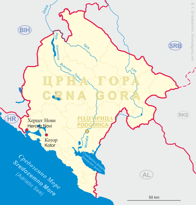
| ЦРНА ГОРА CRNA GORA | MONTENEGRO |
map →
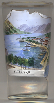
The Montenegrian coastal town of Kotor is located in a secluded part of the Gulf of Kotor. The city has a population of 12,600 (2011) and is the administrative center of Kotor Municipality (population 22,600). Kotor has one of the best preserved medieval old towns in the Adriatic and is a double UNESCO World Heritage Site: it is part of Natural and Culturo-Historical Region of Kotor (inscribed in 1979) and Venetian Works of Defence between the 16th and 17th centuries: Stato da Terra – western Stato da Mar (inscribed 2017).
 The exact time of foundation of the first settlement is not known. According to some sources, the oldest settled area dates
two millennia back, and its current name stems from the word Dekatera (from the old Greek words deka and
thira, meaning 'ten' and 'gate', probably from the number of gates of the fortification). The town, first mentioned
in 168 BC, was settled during Ancient Roman times, when it was known as Acruvium, Ascrivium, or
Ascruvium (Ancient Greek: Ἀσκρήβιον) and was part of the Roman
province of Dalmatia. The town has been fortified since the early Middle Ages, when Emperor Justinian built a fortress
in 535. It was further fortified in the 10th century. It was one of the more influential Dalmatian city-states of romanized
Illyrians throughout the early Middle Ages, and until the 11th century the Dalmatian language was still spoken in Kotor.
The city was part of Byzantine Dalmatia in that period. In 1002 it was occupied by the First Bulgarian Empire and in the
following year was ceded to Duklja, or Dioclea, a vassal duchy of Byzantium at the time. The local population resisted the
pact and, taking advantage of its alliance with Dubrovnik, maintained its high autonomy. Duklja
gradually became more powerful and eventually independent from Byzantium in 1042. The city remained autonomous up until
Duklja was once again subdued by Byzantium in 1143. The city was conquered in 1185 by the Grand Principality of Serbia. At
that time Kotor was already an episcopal see subordinated to the archbishopric of Bari. Kotor became a partially autonomous
city, enjoying many privileges and maintaining its republican institutions. In the 14th century the commerce of Cattaro,
as named in Latin scripts, rivaled that of Republic of Ragusa (Dubrovnik), and caused the Republic of
Venice to be envious. Kotor remained the most important trading port of subsequent Serb states:
Kingdom of Serbia and Serbian Empire, up to its downfall in 1371 upon which the city was taken by the Kingdom of Hungary,
only to change hands repeatedly between them and the Republic of Venice in the period between 1371 and 1384. After that,
Kotor was held by the Kingdom of Bosnia between 1384 and 1391. In 1391 Kotor became independent but asked the Republic of
Venice for protection. The city acknowledged the suzerainty of the Republic of Venice in 1420, becomming part of the
Venetian Albania province from 1420 to 1797. Four centuries of Venetian domination have given the city the typical Venetian
architecture. After the Treaty of Campo Formio in 1797, Cattaro (as it was named in Italian) passed to the Habsburg Monarchy.
However, in 1805, it was assigned to the French Empire's client state, the Napoleonic Kingdom of Italy by the Treaty of
Pressburg (Bratislava). In 1814, Kotor was captured by the British in an attack on the Bay.
Cattaro was restored to the Habsburg Monarchy by the Congress of Vienna in 1815. In World War I, Cattaro was one of
three main bases of the Austro-Hungarian Navy and homeport to the Austrian Fifth Fleet. After 1918, the city became a part
of Yugoslavia and officially became known as Kotor. Between 1941 and 1943 the Kingdom of Italy annexed the area of
Kotor which became one of three provinces of the Italian Governorate of Dalmatia.
The exact time of foundation of the first settlement is not known. According to some sources, the oldest settled area dates
two millennia back, and its current name stems from the word Dekatera (from the old Greek words deka and
thira, meaning 'ten' and 'gate', probably from the number of gates of the fortification). The town, first mentioned
in 168 BC, was settled during Ancient Roman times, when it was known as Acruvium, Ascrivium, or
Ascruvium (Ancient Greek: Ἀσκρήβιον) and was part of the Roman
province of Dalmatia. The town has been fortified since the early Middle Ages, when Emperor Justinian built a fortress
in 535. It was further fortified in the 10th century. It was one of the more influential Dalmatian city-states of romanized
Illyrians throughout the early Middle Ages, and until the 11th century the Dalmatian language was still spoken in Kotor.
The city was part of Byzantine Dalmatia in that period. In 1002 it was occupied by the First Bulgarian Empire and in the
following year was ceded to Duklja, or Dioclea, a vassal duchy of Byzantium at the time. The local population resisted the
pact and, taking advantage of its alliance with Dubrovnik, maintained its high autonomy. Duklja
gradually became more powerful and eventually independent from Byzantium in 1042. The city remained autonomous up until
Duklja was once again subdued by Byzantium in 1143. The city was conquered in 1185 by the Grand Principality of Serbia. At
that time Kotor was already an episcopal see subordinated to the archbishopric of Bari. Kotor became a partially autonomous
city, enjoying many privileges and maintaining its republican institutions. In the 14th century the commerce of Cattaro,
as named in Latin scripts, rivaled that of Republic of Ragusa (Dubrovnik), and caused the Republic of
Venice to be envious. Kotor remained the most important trading port of subsequent Serb states:
Kingdom of Serbia and Serbian Empire, up to its downfall in 1371 upon which the city was taken by the Kingdom of Hungary,
only to change hands repeatedly between them and the Republic of Venice in the period between 1371 and 1384. After that,
Kotor was held by the Kingdom of Bosnia between 1384 and 1391. In 1391 Kotor became independent but asked the Republic of
Venice for protection. The city acknowledged the suzerainty of the Republic of Venice in 1420, becomming part of the
Venetian Albania province from 1420 to 1797. Four centuries of Venetian domination have given the city the typical Venetian
architecture. After the Treaty of Campo Formio in 1797, Cattaro (as it was named in Italian) passed to the Habsburg Monarchy.
However, in 1805, it was assigned to the French Empire's client state, the Napoleonic Kingdom of Italy by the Treaty of
Pressburg (Bratislava). In 1814, Kotor was captured by the British in an attack on the Bay.
Cattaro was restored to the Habsburg Monarchy by the Congress of Vienna in 1815. In World War I, Cattaro was one of
three main bases of the Austro-Hungarian Navy and homeport to the Austrian Fifth Fleet. After 1918, the city became a part
of Yugoslavia and officially became known as Kotor. Between 1941 and 1943 the Kingdom of Italy annexed the area of
Kotor which became one of three provinces of the Italian Governorate of Dalmatia.
[https://en.wikipedia.org/wiki/Kotor]
![[scale]](lineal.jpg)