
|
|
| DEUTSCHLAND | GERMANY |
| Bundesland: Baden-Württemberg | |
| Regierungsbezirk: Karlsruhe | |
| Landkreis: Karlsruhe |
map →

 Liedolsheim is situated at an elevation of 99 m about 28 km north of Karlsruhe
in northern Baden-Württemberg. Together with Ru&szig;heim it forms the municipality of Dettenheim. The municipality
as a whole has a population of about 6,600 (2018).
Liedolsheim is situated at an elevation of 99 m about 28 km north of Karlsruhe
in northern Baden-Württemberg. Together with Ru&szig;heim it forms the municipality of Dettenheim. The municipality
as a whole has a population of about 6,600 (2018).
Rußheim was first mentioned in AD 784. The name Dettenheim goes back to a village that was located directly at the river Rhine at a place that still is part of the modern municipality; that old village, however, was abandoned in 1813 and its inhabitants founded the new village Karlsdorf (today part of Karlsdorf-Neuthard). In 1975 the formerly independent municipalities of Liedolsheim and Rußheim were merged into the new municipality Liedolsheim-Rußheim. The name was changed to the historic Dettenheim in 1978.
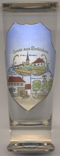
The Protestant  church in Liedolsheim [left, no.3883: top picture]
was first mentioned in 1365. The tower was built around 1400. The church as we see it today was mostly rebuilt in 1737,
the tower was heightened in 1887. The building to the right of the church is the parsonage.
church in Liedolsheim [left, no.3883: top picture]
was first mentioned in 1365. The tower was built around 1400. The church as we see it today was mostly rebuilt in 1737,
the tower was heightened in 1887. The building to the right of the church is the parsonage.
The building depicted on the bottom left picture is labeled
Geschäftshaus
The soldiers' monument [bottom right picture] was created to commemorate
the Franco-Prussian War of 1870/1870. The monument was originally located in front of the village church and was later
relocated to its present location in the cemetary behind the church.
[https://de.wikipedia.org/wiki/Dettenheim;
http://fallingrain.com/world/GM/01/Liedolsheim.html;
https://www.kirche-liedolsheim.de/index.php/wir-stellen-uns-vor, https://www.ekiba.de/html/aktuell/aktuell_u.html?&m=31&artikel=6448&cataktuell=407;
https://www.dettenheim.de/news/1/365035/nachrichten/kriegsdenkmal.html?browser=1]
![[scale]](lineal.jpg)