
|
|
| DEUTSCHLAND | GERMANY |
| Bundesland: Freistaat Bayern | Bavaria |
| Regierungsbezirk: Oberfranken | |
| Landkreis: Bayreuth |
map →

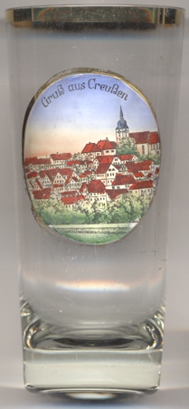 Creußen is situated at an elevation of 442 m in the Fränkische Schweiz ('Frankonian Switzerland'), a low mountain region
in northern Bavaria, about 13 km south of the district town Bayreuth. The municipality has a population of about
5,000 (2020).
Creußen is situated at an elevation of 442 m in the Fränkische Schweiz ('Frankonian Switzerland'), a low mountain region
in northern Bavaria, about 13 km south of the district town Bayreuth. The municipality has a population of about
5,000 (2020).
The oldest known written document that mentions Urbs Crusni dates from 1003. The burgraves of Nuremberg came in possession of the place in 1251. In 1358 Creußen obtained the privileges as a town. The last margrave of Brandenburg-Ansbach-Bayreuth sold his territories to Prussia in 1791. Between 1807 and 1810 the margraviate was part of France, and thereafter became part of the Kingdom of Bavaria.
The  parish church Sankt Jakobus [background right] goes back to a previous church that likely
already existed in the 11th century. That old church was destroyed in 1430 during the Hussite Wars. The church was then rebuilt until 1477.
The tower was heightened in 1567 but damaged by a fire in 1633. The roof of the tower was restored only in 1643. The nave was heightened in the late
17th century.
parish church Sankt Jakobus [background right] goes back to a previous church that likely
already existed in the 11th century. That old church was destroyed in 1430 during the Hussite Wars. The church was then rebuilt until 1477.
The tower was heightened in 1567 but damaged by a fire in 1633. The roof of the tower was restored only in 1643. The nave was heightened in the late
17th century.
[https://de.wikipedia.org/wiki/Creu%C3%9Fen;
https://de.wikipedia.org/wiki/St._Jakobus_(Creußen)]
![[scale]](lineal.jpg)