
|
|
| DEUTSCHLAND | GERMANY |
| Bundesland: Niedersachsen | Lower Saxony |
| Landkreis: Grafschaft Bentheim |
map →
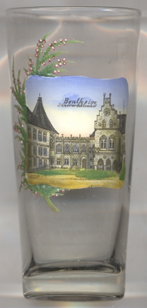
Bad Bentheim is situated at an elevation of 49 m in the southwest of Germany's state of Lower Saxony in the district Grafschaft Bentheim ("County Bentheim", refering to the historical entity), about 16 km south of the district town Nordhorn and 175 km west of the state's capital, Hannover. The municipality has a population of about 15,800 (2020).
The oldest known written document that mentions Binithem dates from 1050. For centuries, the market town was the center of the county of the same name. Under Prussian rule, Bentheim was an 'Amt' (administrative district) and from 1857 to 1973 the seat of a district court. In 1865, Bentheim obtained the rights of a town. In 1945, the British military government relocated the district seat to the geographically more central town of Nordhorn. After World War II, the whole area, along with many other border areas in Germany, would have been annexed by the Netherlands under the Bakker-Schut plan in 1945, but this plan was scuttled by US objections. In 1929, the communities Bentheim-Bauerschaft and the estate district Bentheim, Schloss were incorporated into Bentheim. As part of the municipal area reform in Lower Saxony in 1974, the town of Bentheim, the Samtgemeinde (a collective association of municipalities) of Gildehaus (consisting of the member municipalities of Gildehaus, Achterberg, Hagelshoek, Holt and Haar, Waldseite and Westenberg) and the municipalities of Bardel and Sieringhoek were merged to form the Einheitsgemeinde (unified municipality) Stadt Bentheim. In 1979, the prefix Bad was added to the municipality's name, recognising its status as a spa town. The constituent community of Gildehaus was recognised as a state-recognized health resort (Erholungsort) in 1982.
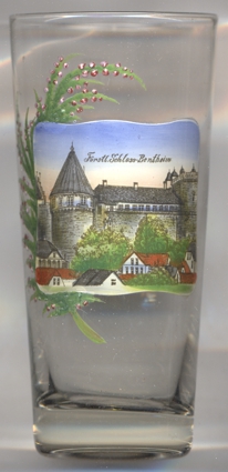
 Bentheim Castle
is built on a protrusion of Bentheim sandstone, which not only provided building materials for the castle itself, but was also a valued export product.
The earliest history of the castle, which was erected on the remains of an earlier refuge castle, is largely unknown. In the registries of Werden Abbey
(1050) the castle is mentioned as Binedheim. This stronghold, believed to have been built from wood, not stone, was completely destroyed in 1116.
A new stone castle was soon erected in the same place. After 1146 the castle became a fee of the diocese of Utrecht. In 1154, the castle (and in 1165
also the county) passed into the hands of the Counts of Holland (counts of Bentheim-Holland). Counts of Bentheim were mentioned since 1421, and in
1486 the county became an independent political entity. The main tower of the castle was built between 1588 and 1593. Large parts of the castle were
destroyed again during the Thirty Years' War (1618–1648) and the Seven Years' War (1756–1763). The castle today is still owned by the
counts of Bentheim-Steinfurt whose main residence is Steinfurt. Nevertheless, parts of the family live in Bentheim Castle. The castle is also open to
the public as a family museum.
Bentheim Castle
is built on a protrusion of Bentheim sandstone, which not only provided building materials for the castle itself, but was also a valued export product.
The earliest history of the castle, which was erected on the remains of an earlier refuge castle, is largely unknown. In the registries of Werden Abbey
(1050) the castle is mentioned as Binedheim. This stronghold, believed to have been built from wood, not stone, was completely destroyed in 1116.
A new stone castle was soon erected in the same place. After 1146 the castle became a fee of the diocese of Utrecht. In 1154, the castle (and in 1165
also the county) passed into the hands of the Counts of Holland (counts of Bentheim-Holland). Counts of Bentheim were mentioned since 1421, and in
1486 the county became an independent political entity. The main tower of the castle was built between 1588 and 1593. Large parts of the castle were
destroyed again during the Thirty Years' War (1618–1648) and the Seven Years' War (1756–1763). The castle today is still owned by the
counts of Bentheim-Steinfurt whose main residence is Steinfurt. Nevertheless, parts of the family live in Bentheim Castle. The castle is also open to
the public as a family museum.
[https://de.wikipedia.org/wiki/Bad_Bentheim, https://en.wikipedia.org/wiki/Bad_Bentheim;
https://en.wikipedia.org/wiki/Bentheim_Castle, https://de.wikipedia.org/wiki/Burg_Bentheim]
![[scale]](lineal.jpg)