
|
|
| DEUTSCHLAND | GERMANY |
| Bundesland: Baden-Württemberg | |
| Regierungsbezirk: Tübingen | |
| Landkreis: Bodenseekreis |
map →

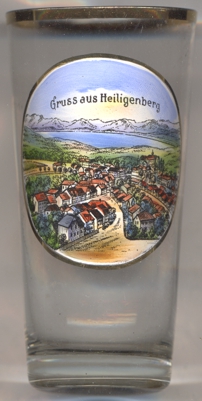 Heiligenberg is situated at an elevation of 726 m in the upper Linzgau region in the northwest of the Bodenseekreis district, about
22 km northwest of the district town Friedrichshafen. The municipality has a population of about 3,100 (2021).
Heiligenberg is situated at an elevation of 726 m in the upper Linzgau region in the northwest of the Bodenseekreis district, about
22 km northwest of the district town Friedrichshafen. The municipality has a population of about 3,100 (2021).
The earliest traces of human inhabitants date from the Stone Age period. The region was christianised around 600 AD. It is not known whether the name Heiligenberg dates from this period or whether a pre-christian place of worship had already existed earlier. The oldest written mention of Mons Sanctus dates from 1083. In the 13th century, the lords of the Linzgau built a castle, which later became the seat of the counts of Heiligenberg, later Werdenberg-Heiligenberg. In 1535 the domains were acquired by the princes of Fürstenberg. From 1664 until the mediatisation of 1806, the principality of Fürstenberg was an independent principality within the Holy Roman Empire and Heiligenberg from 1664 until 1716 was the main residence. Heiligenberg castle still today is in possession of the family. The present municipality was created in 1975 out of the former municipalities of Hattenweiler, Heiligenberg and Wintersulgen. Until 1972 Heiligenberg was part of the district Überlingen, which in 1973 was merged with the former district Tettnang.
Heiligenberg also is the former German name of the Czech pilgrimage site
Svatý Kopeček.
[https://de.wikipedia.org/wiki/Heiligenberg_(Bodenseekreis, https://de.wikipedia.org/wiki/F%C3%BCrstentum_F%C3%BCrstenberg;
https://de.wikipedia.org/wiki/Bodenseekreis]
![[scale]](lineal.jpg)