
|
|
| DEUTSCHLAND | GERMANY |
| Bundesland: Niedersachsen | Lower Saxony |
| Landkreis: Lüneburg |
map →
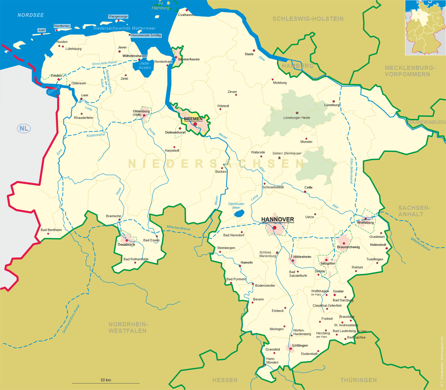
Lüneburg is situated at an elevation of 17 m on the river Ilmenau, about 30 km upstream of its confluence with the river Elbe, about 107 km northeast of Hannover, about 109 km eastnortheast of Bremen, and about 44 km southeast of Hamburg. To the southwest of the town stretches the 7,400-square-kilometre Lüneburger Heide (Lüneburg Heath), which emerged as a result of widespread tree-felling, forest fires and grazing. The tradition that the heath arose from centuries of logging undertaken to meet the constant need of the Lüneburg salt works for wood is not historically confirmed. More likely, the heath was originally formed by clearances during the Bronze Age. The municipality has a population of about 75,600 (2021).
 The first signs of human presence in the area of Lüneburg date back to the time of Neanderthal Man: 56 axes, estimated at 150,000 years old, were
uncovered in the 1990s. Since the Bronze Age, the Lüneburg hill known as the Zeltberg has concealed a whole range of prehistoric and early historic
graves. The ancient town may be that identified as Λευφάνα (Leuphana), a town listed in the
2nd century by Ptolemy. Luniburc was first mentioned in a written document in 956 AD. There is also an older reference to
ad locum, qui dicitur Hliuni in 795&bsp;AD. which likely refers to Lüneburg castle. In spite of its lucrative saltworks, Lüneburg was
originally subordinated to the town of Bardowick only a few miles to the north. Bardowick was older and was an important trading post for the Slavs. Only
when Bardowick refused to pay allegiance to Henry the Lion it was destroyed by him in 1189, whereupon Lüneburg was given town privileges and
developed into the central trading post in the region. As a consequence of the monopoly that Lüneburg had for many years as a supplier of salt within
the North German region, it very quickly became a member of the Hanseatic League of trading towns. Around the year 1235, the Duchy of
Braunschweig-Lüneburg emerged, with Lüneburg as its residence. However, 1371, in the wake of the Lüneburg War of
Succession, the rebel citizens of the town destroyed the residence and with the treaty of 1392 obtained the privileges of a free imperial town, a status
they were able to defend until 1637. With the demise of the Hanseatic League in the 16th/17th century the town gradually impoverished. The town became part
of the Electorate of Hannover in 1708, the Kingdom of Westphalia in 1807, the First French Empire in 1810, the Kingdom of Hannover in 1814, and the Prussian
Province of Hannover in 1866. In 1945 Lüneburg surfaced once again in the history books when, south of the town on the hill known as the Timeloberg
(near the village of Wendisch Evern) the German Instrument of Surrender was signed that brought World War II in Europe to an end. After the war,
Lüneburg became part of the new German state of Niedersachsen (Lower Saxony).
The first signs of human presence in the area of Lüneburg date back to the time of Neanderthal Man: 56 axes, estimated at 150,000 years old, were
uncovered in the 1990s. Since the Bronze Age, the Lüneburg hill known as the Zeltberg has concealed a whole range of prehistoric and early historic
graves. The ancient town may be that identified as Λευφάνα (Leuphana), a town listed in the
2nd century by Ptolemy. Luniburc was first mentioned in a written document in 956 AD. There is also an older reference to
ad locum, qui dicitur Hliuni in 795&bsp;AD. which likely refers to Lüneburg castle. In spite of its lucrative saltworks, Lüneburg was
originally subordinated to the town of Bardowick only a few miles to the north. Bardowick was older and was an important trading post for the Slavs. Only
when Bardowick refused to pay allegiance to Henry the Lion it was destroyed by him in 1189, whereupon Lüneburg was given town privileges and
developed into the central trading post in the region. As a consequence of the monopoly that Lüneburg had for many years as a supplier of salt within
the North German region, it very quickly became a member of the Hanseatic League of trading towns. Around the year 1235, the Duchy of
Braunschweig-Lüneburg emerged, with Lüneburg as its residence. However, 1371, in the wake of the Lüneburg War of
Succession, the rebel citizens of the town destroyed the residence and with the treaty of 1392 obtained the privileges of a free imperial town, a status
they were able to defend until 1637. With the demise of the Hanseatic League in the 16th/17th century the town gradually impoverished. The town became part
of the Electorate of Hannover in 1708, the Kingdom of Westphalia in 1807, the First French Empire in 1810, the Kingdom of Hannover in 1814, and the Prussian
Province of Hannover in 1866. In 1945 Lüneburg surfaced once again in the history books when, south of the town on the hill known as the Timeloberg
(near the village of Wendisch Evern) the German Instrument of Surrender was signed that brought World War II in Europe to an end. After the war,
Lüneburg became part of the new German state of Niedersachsen (Lower Saxony).
 Sankt Johannis (church of St. John the Baptist) is the oldest Lutheran church in Lüneburg. The church is
considered an important example of northern German Brick Gothic architecture. The five-naved hall church was erected between 1300 and 1370 and repaired
in 1420. In the early 15th century, the prince-bishop of Verden (Verden an der Aller), failed to make St. John's the new cathedral of his see,
since the city council and the Prince of Lüneburg resisted that fearing the political interference of another power. The outer structure was marked
by rebuilding in 1765. Particularly striking is the lightly sloping steeple, which at a height of 108 meters is the highest church steeple in Lower
Saxony.
Sankt Johannis (church of St. John the Baptist) is the oldest Lutheran church in Lüneburg. The church is
considered an important example of northern German Brick Gothic architecture. The five-naved hall church was erected between 1300 and 1370 and repaired
in 1420. In the early 15th century, the prince-bishop of Verden (Verden an der Aller), failed to make St. John's the new cathedral of his see,
since the city council and the Prince of Lüneburg resisted that fearing the political interference of another power. The outer structure was marked
by rebuilding in 1765. Particularly striking is the lightly sloping steeple, which at a height of 108 meters is the highest church steeple in Lower
Saxony.
The square depicted in the foreground is named Am Sande. The square is about 225 metres long and
about 30–40 metres wide, stretching in a west–east direaction. The place was first mentioned in 1229 as in harena. The place was
originally not paved, hence the name Am Sande ('at the sand'). The square was created as a connection between the Modestorpe settlement, the
Kalkberg settlement and the saltworks. In addition, the trade route to Magdeburg and Braunschweig as
well as to Hamburg and Lübeck ran here. Due to the trade routes, the square became a trading center
for goods. Still today, the square is surrounded by predominantly medieval town houses with their Gothic staircases and curved Baroque snail gables.
[https://de.wikipedia.org/wiki/L%C3%BCneburg, https://en.wikipedia.org/wiki/L%C3%BCneburg;
https://en.wikipedia.org/wiki/St._John%27s_Church,_L%C3%BCneburg;
https://de.wikipedia.org/wiki/Am_Sande]
![[scale]](lineal.jpg)