
|
|
| DEUTSCHLAND | GERMANY |
| Bundesland: Freistaat Bayern | Bavaria |
| Regierungsbezirk: Oberbayern | |
| Landkreis: Rosenheim |
map →

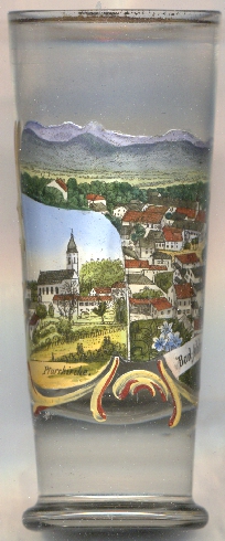 Bad Aibling is situated at an elevation of 492 m in the basin of the 'Rosenheimer See', a lake that had formed at the end of the
Würm glaciation about 10,000 ago, about 44 km southeast of Munich and about 9 km west of the district town
Rosenheim. The municipality has a population of about 19,200 (2021).
Bad Aibling is situated at an elevation of 492 m in the basin of the 'Rosenheimer See', a lake that had formed at the end of the
Würm glaciation about 10,000 ago, about 44 km southeast of Munich and about 9 km west of the district town
Rosenheim. The municipality has a population of about 19,200 (2021).
Bad Aibling and its surroundings were settled by Celtic tribes from about 500 BC, the Romans settled here in 15 BC. It was finally settled by Bavarii tribes in the 5th century AD. In 804 Bad Aibling was mentioned for the first time as Epininga. In mediaeval times, it was an administrative centre in the lordship of the counts of Falkenstein. The name Aiblingen was first mentioned in 1166. After the counts of Falkenstein became extinct in 1272, Aibling came in possession of the Wittelsbach dynasty. In 1845 the first treatments with peat pulp were offered and in 1895 Aibling received the predicate Bad (spa). In 1933 bad Aibling officially obtained the status of a town.
The  parish church Mariä Himmelfahrt (Assumption of Our Lady) [left, no. 4306: bottom left inset]
in its core dates from around 1431. The old church was remodeled in 1663 and rebuilt in 1755/1756 in Baroque style.
parish church Mariä Himmelfahrt (Assumption of Our Lady) [left, no. 4306: bottom left inset]
in its core dates from around 1431. The old church was remodeled in 1663 and rebuilt in 1755/1756 in Baroque style.
[https://de.wikipedia.org/wiki/Bad_Aibling, https://en.wikipedia.org/wiki/Bad_Aibling;
https://de.wikipedia.org/wiki/Mari%C3%A4_Himmelfahrt_(Bad_Aibling)]
![[scale]](lineal.jpg)